Mackay-Whitsunday
Mackay-Whitsunday
The Mackay-Whitsunday region comprises an area of almost 940,000 ha and extends from Adelaide Point (Edgecumbe Bay) in the north to Clairview (Clairview Bluff) in the south and includes several large continental islands. The region includes the major population centres of Mackay, Proserpine, Airlie Beach and Sarina; encompassing the Proserpine, O’Connell, Pioneer and Plane river basins1.
Seagrasses are a major component of the Mackay-Whitsunday marine ecosystems, delivering a number of ecosystem contributions (goods and benefits) from the material, regulating and non-material categories. Extensive seagrass meadows occur on intertidal mudflats and in nearshore and offshore subtidal areas in the region. Approximately 448 km2 of seagrass habitat has been mapped in the region since the 1980s, with 154 km2 in shallow waters and 293 km2 in deeper (>15m) waters3.
The Great Barrier Reef protects the coastline from predominantly south-easterly winds which often accompany a light south-easterly ocean swell2. Located in the northern section of the region is the Whitsunday Islands, a collection of wet drowned mountains situated close to the east coast of Queensland, Australia. The Whitsundays was named by Captain James Cook, who traveled through the area on Sunday 4 June 1770, which happened to be Whit Sunday (the seventh Sunday after Easter. The traditional owners of the area are the Ngaro people and the Gia people whose Juru people has the only legally recognised native title in the region.
The Whitsundays is a network of 74 islands of which 7 have resort facilities. Beyond the resorts the whole area is part of the Great Barrier Reef Marine Park and the uninhabited islands are all controlled by National Parks and Wildlife.
Coastal waters adjacent to the large rivers and mangrove-lined inlets are generally very turbid and shallow, with predominantly mud sediments. Tidal range in the south of the region is large, and in some places has the effect of creating extensive tidal banks. The region receive rainfall between 500-3000 mm annually, which falls mostly (~70 per cent) from December to March. Average daily temperatures for Mackay range between 23 31°C in January and 11-22°C in July. The major land use of each catchment is livestock grazing, and crops such as sugar cane.
Thirteen species of seagrass have been recorded in the Mackay-Whitsunday, representing 80 per cent of the known species found in Queensland waters5. The wide range of physical habitats where seagrasses were found undoubtedly contributes to the high species diversity. Habitats include intertidal and subtidal areas of estuary, coastal fringing reef environments and deepwater environments. MMP sites are located on three of the generalised seagrass habitats represented in the region, including estuarine, coastal and reef. For a detailed description of seagrass meadows and habitats across the region5.
Conceptual diagrams of regional seagrass habitats
Estuarine seagrass habitats in the Mackay-Whitsunday region tend to be intertidal on the large sand/mud banks of sheltered estuaries. Run-off through the catchments connected to these estuaries is variable, though the degrees of variability is moderate compared to the high variability of the Burdekin and the low variability of the Tully, further north 6. Seagrass in this habitat must cope with extremes of flow, associated sediment and freshwater loads from December to April when 80% of the annual discharge occurs
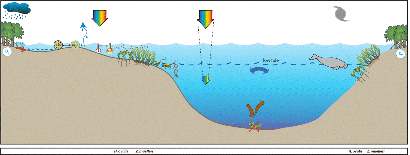
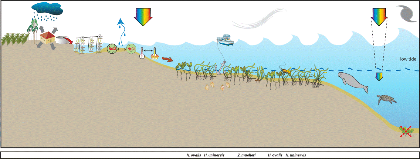
Reef habitat seagrass meadows are found on the shallow fringing reefs adjacent to the mainlands or associated with the many islands in this region. The drivers of these habitats is exposure to waves and temperature extremes. Major threats would be increased tourism activities including marina and coastal developments.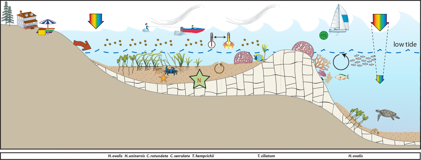
Marine Monitoring Program
2019 -2020 Summary
SEAGRASS STATUS 2019-2020 20
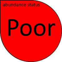
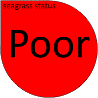
Inshore seagrass meadows across the Mackay–Whitsunday NRM region increased in overall condition in 2019–20, but the condition grade remained POOR. Although there was a small increase in all indicators, the conditions contributing to this were:
- abundance score was POOR
- reproductive effort score was POOR
- tissue nutrient score was POOR
Nearly three quarters of sites either increased or remained unchanged in abundance in 2019–20 relative to the previous period. The greatest losses occurred in the coastal subtidal habitat, although only a single location in the region is assessed. Overall, the long-term trend indicates a declining trajectory, however improvements over the last two years indicate a region nearly recovered to 2016-17 levels, following the losses experienced in early 2017.
Seagrass reproductive effort declined slightly at coastal habitats, and improved in all other habitats. Reproductive effort at the estuarine site is highly variable both inter-annually and seasonally, but there are usually some reproductive structures observed in the dry season. Seeds are persisting within the seed bank of all habitats, which provides some capacity to recover from future impacts.
The Mackay–Whitsunday regional seagrass condition had been improving from 2010–2011, when it reached its lowest level since monitoring commenced to 2016–2017. After this time, the recovery trend abated as a consequence of cyclone Debbie. In 2019–20, the score returned to the 2015–16 level, but remained poor. Moderate rainfall and discharge, as well as near average water temperatures in 2019–20 are conditions that likely supported this recovery. Continued improvement and return to a moderate or good state will depend of favourable conditions and alleviated pressures in future.
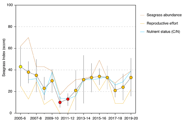
Report card of seagrass status indicators and index for the Mackay–Whitsunday NRM region (averages across habitats and sites). Values are indexed scores scaled from 0–100 (± SE) and graded: ● = very good (81-100), ● = good (61 – 80), ● = moderate (41 – 60), ● = poor (21 – 40), ● = very poor (0 – 20). NB: Scores are unitless.
CLIMATE AND ENVIRONMENTAL PRESSURES 2019-2020 20
The 2019–20 monitoring period in the Mackay–Whitsunday region was relatively benign with environmental pressures around or below the long-term averages. It was characterised by rainfall and discharge that was below the long-term average.
- No tropical cyclones affected the region during the period.
- Exposure of inshore seagrass to turbid waters during the wet season above the long-term average.
- Exposure to either ‘brown’ or ‘green’ turbid water was variable among seagrass habitats. Estuarine and coastal sites were not only exposed to turbid waters for the entire wet season, but were the only habitats exposed to ‘brown’ sediment laden waters.
- Estuarine sites in Sarina Inlet (SI1 and SI2), were exposed to ‘brown’ turbid water for 100 per cent of the wet season.
- Reef habitats fringing the mainland (HB1 and HB2) and located on offshore islands (HM1 and HM2, LN1 and LN2) were exposed primarily to ‘green’ water though with some ‘brown’ water at coastal reef sites, and sometimes neither ‘brown’ or ‘green’ at the reef sites on reef tops.
- Within-canopy light was slightly higher (12.4 mol m-2 d-1) than the long-term average (11.9 mol m-2 d-1) for all sites combined within the region. At a site level, benthic light was higher than average at all sites.
- The single biggest increase was at the estuarine site at Sarina Inlet where light was 3 mol m-2 d-1 higher than the long-term average for the site caused by an extended dry season increase in light, and a high maximum light level.
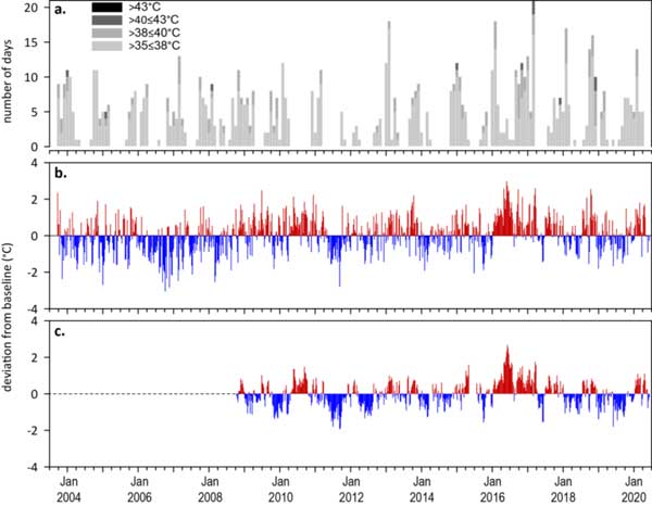
- 2019–20 was the seventh consecutive year intertidal within-canopy temperatures were above the long-term average, but the difference was marginal. Maximum intertidal within-canopy temperatures exceeded 35°C for a total of 68 days during 2019–20, with the highest temperature recorded at 41.1°C (MP2, 10Feb20).
2018–19 was the third full year of subtidal monitoring with an annual average temperature of 25.5°C, and maximum of 31.1°C (2pm 20Feb20). Daily tide exposure was above the long‐term average in 2018–19 for the second consecutive year, which may have exacerbated the stresses from the marginally higher water temperatures experienced at intertidal sites.
Location
Cid Harbour
Monitoring: ongoing
Principal watchers: QPWS Central Region
Past watchers: Elmer Ten-Haken, Jacquie Shiels, Tony Fontes and Seagrass-Watch HQ.
Location: subtidal banks on the north-western coast of Whitsunday Island (Hook Is to Daniel Point)
Site code: CH1, CH2, CH3, CH4, CH5
Issues: increasing commercial and recreational vessel movement, anchor impacts
Comments: important foraging habitat for green sea turtles and dugongs.
- Monitoring was reinstated at CH4 and CH5 in 2021 using drop-camera assessments.
- Seagrass abundance across the Cid Harbour meadows declined between 2000 and 2004.
- Abundances at Cid Harbour in December 2021 were similar to those last reported in 2004 before monitoring was suspended.
- The meadow on the north-western coast of Whitsunday Island adjacent to Cid Harbour is one of the largest in the region, extending 5.6 km along the coast and 3.4 km perpendicular from the coast (1432.7±113 ha)
- Meadow appears to show fairly typical season pattern of seagrass abundance (higher in late spring-summer than winter).
- Cid Harbour meadows consist mainly of Halodule uninervis (wide leaf form) found in association with Cymodocea serrulata, Halophila spinulosa and Halophila ovalis. A spring-summer increase in the proportion of H. spinulosa occurred in some of the meadow, suggestive of its preference for high light conditions. Halodule uninervis remained the dominant species across most of the meadow. Low proportions of H. ovalis and negligible S. isoetifolium indicate little disturbance within the meadow.
- Epiphyte and algae cover generally higher in spring (September), reflecting a seasonal response to increasing light and temperature.
- Epi-fauna attached to seagrass blades are common throughout the Cid Harbour meadow and consisted mostly of ascidians and forams. Sponges were also common throughout the area
- Sediments at Cid Harbour sites were composed of fine mud, sand and shell with a high organic component. Disturbance from boat anchors at Cid Harbour sites was minimal.
- Turtle and dugong grazing common from September to February.
Seagrass cover, species composition and Macroalgae
Location
Dingo Beach
Monitoring: ad hoc
Principal watchers: Jacquie Shiels, Heather Marshall, Shenna Barrett, Elmer Ten-Haken
Past watchers: Avril Ayling, Tony Ayling , Margaret Parr, Geoff Bunn, Valerie Bunn, Wendy Galloway, Betty Wilson, Carolyn Williams, Dianne Turner, Jean Wells, Joyce Patullo and Seagrass-Watch HQ
Location: intertidal sand flats in north facing mainland bay, in the north of the region
Site code: DB1, DB2

Issues: urban expansion, sewage and groundwater, siltation due to clearing and erosion
Comments: approximately 55ha of seagrass meadows has been mapped in the bay since 1987. Meadows are predominately Halodule uninervis with Halophila ovalis. Other species (including Thalassia hemprichii, Syringodium isoetifolium and Cymodocea serrulata) are present within the bay. There are no major rivers flowing into this coastal section and a high proportion of the catchment in this region is covered with native terrestrial vegetation. Negative impacts from catchment inputs and urban and agricultural development are likely to be low. The abundance of seagrass in the region represents a significant food source and valuable habitat for green sea turtle and dugong moving between Edgecumbe Bay and the Whitsunday Islands.
- Sites were last assessed on 17 May 2019.
- seagrass cover continues to recover from the losses experienced in early 2017, as a consequence of tropical cyclone Debbie.
- Abundance appears to follow a typical seasonal pattern (higher in late spring-summer than winter).
- sites dominated by Halodule uninervis with some Halophila ovalis
- seagrass species composition has remained relatively stable over the monitoring period, indicative of natural and/or anthropogenic disturbance.
- Halodule seed bank status is currently unknown as no assessment since 2007.
- macroalgae cover generally low and below GBR long-term average for coastal habitats.
- gastropods, hermit crabs and polychaete worms were generally common at Dingo Beach. The high abundance of invertebrate fauna at these sites suggested that seagrass provides an adequate supply of detritus, grazing matter and faunal prey.
Seagrass cover, species composition and canopy height
Location
Hamilton Island
Monitoring: ongoing, biannual (MMP)
Principal watchers: Seagrass-Watch HQ
Location: intertidal sand flats at either end of Catseye Bay
Site codes: HM1, HM2, HM3
Issues: sewage and groundwater
Comments: Hamilton Island is the largest inhabited and most developed island in the region. Apart from the resort and village, much of the 750 hectares is still untouched. The island is also surrounded by fringing coral reefs, the largest in Catseye Bay in front of the main resort.
Nine seagrass species can be found in Catseye Bay: Halodule uninervis and Halophila ovalis are scattered over the sandy intertidal areas; patches of Zostera muelleri occur in the intertidal areas at the eastern end of the bay; Thalassia hemprichii, Cymodocea serrulata and Cymodocea rotundata are mixed in amongst the coral on the reef flat; Syringodium isoetifolium is present on the outer edge of the reef flat in the shallow subtidal waters; Halophila spinulosa occurs just over the edge of the reef crest in deeper waters (>3m); and on the shoreward edge of the coral area are small patches of rare Thalassodendron ciliatum (one of the southern-most occurrences of this species in the Pacific).
The seagrasses in Catseye Bay provide shelter for fish and prawns and food for green sea turtles.
- although seagrass abundance has fluctuated between and within years, in the long-term seagrass has declined at both sites.
- seagrass cover has been consistently POOR since monitoring was established in 2007
- HM1 is dominated by Halodule uninervis, with some Halophila ovalis, and located in front of the main resort within an area where motorised vessels are prohibited. HM2 is in the far east of the Bay and was dominated by Zostera mulleri with Halodule uninervis and Halophila ovalis. This site has relatively no impacts from boating or resort activities.
- The seagrass species composition has remained relatively stable at HM1 over the monitoring period, however at HM2, the composition of Halophila has fluctuated, indicative of natural and/or anthropogenic disturbance.
- macroalgae cover generally low and below GBR long-term average for reef habitats.
Seagrass cover, species composition and canopy height
Seagrass Cover: Timeseries of seagrass cover. Mean and standard error of site level observations shown. Timing of impacts attributed to acute disturbance events (Tropical cyclones) are indicated by vertical lines and disturbance symbol ֎ .
Seagrass Composition: Mean composition of each seagrass species during each sampling event.
Plots are interactive with mouse-over features providing additional detail.
Location
Hydeaway Bay
Monitoring: ongoing (MMP)
Principal watchers: Jacquie Shiels, Heather Marshall, Shenna Barrett, Elmer Ten-Haken, Seagrass-Watch HQ
Occasional and past watchers: Maren Mathews, Sunnee Goudy, Margaret Parr, Valerie Bunn, Yvonne Chaloner, Avril Ayling, John Williams, Dell Williams and Wendy Galloway
Location: large fringing reef-flat in north facing mainland bay, in the north of the region
Site codes: HB1 & HB2
Issues: Urban expansion, sewage and groundwater, siltation due to clearing and erosion
Comments: Hydeaway Bay meadows cover approximately 157ha and are predominately mixed meadows of Halodule uninervis, Halophila ovalis, Cymodocea rotundata and Thalassia hemprichii. There are no major rivers flowing into this coastal section and a high proportion of the catchment in this region is covered with native terrestrial vegetation. Negative impacts from catchment inputs and urban and agricultural development are likely to be low. The abundance of seagrass in the region represents a significant food source and valuable habitat for green sea turtle and dugong moving between Edgecombe Bay and the Whitsundays.
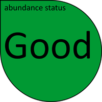
- Seagrass abundance declined at both sites from 2009 to 2011, but started to recover from 2015. Abundances in late 2011 were the lowest reported since monitoring was established. Apart from a short decline in 2017, a consequence of TC Debbie, seagrass abundances have been in a Fair to Good state. Over the past two decades, however, seagrass abundance has declined at HB1, while no long-term trend is apparent at HB2.
- Seagrass abundance follows a seasonal trend, characterised by maximum cover (>20% cover) in summer/autumn (December –April) and minimum cover (<20% cover) in winter (June-July). This suggests that seagrass meadows at these sites are primarily influenced by natural factors (temperature, light, wave action).
- Seagrass species composition prior to 2009 was remained relatively stable over the monitoring period, however, over the last few years the increased composition of Halophila and Halodule is indicative of natural and/or anthropogenic disturbance.
- Maximum epiphyte cover (>35-75%) occurs in summer (December) and autumn (March), and minima in winter. Algal cover remained below 20% with no seasonal pattern. High epiphyte cover in spring-summer may have been caused by high water temperatures and light availability. High rainfall during summer may also enrich waters with nutrients necessary for epiphyte growth.
- The presence of large sea cucumbers present across the reef flat at both sites is a significant feature.
- Sites are comprised of fine to coarse sand sediments, exposed to wave action. Sediments have a low proportion of organic matter and seagrasses compete for space with corals (soft and hard) and macroalgae.
- Abundance data contributes to the Great Barrier Reef Marine Monitoring Program
Seagrass cover, species composition and canopy height
Seagrass Cover: Timeseries of seagrass cover. Mean and standard error of site level observations shown. Timing of impacts attributed to acute disturbance events (Tropical cyclones) are indicated by vertical lines and disturbance symbol ֎ .
Seagrass Composition: Mean composition of each seagrass species during each sampling event.
Plots are interactive with mouse-over features providing additional detail.
Location
Laguna Quays
Monitoring: suspended
Past watchers: Margaret Parr, Geoff Bunn Betty Wilson, John Thornely, Carolyn Williams and Seagrass-Watch HQ
Location: sand/mud flat along western coast of Repulse Bay, 3km south of O’Connell River mouth
Site Codes: MP1, MP4
Issues: Resort and marina development, vessel traffic near dugong and turtle habitat, catchment inputs from agriculture, mangrove clearing
Comments: Dugong and turtle feeding grounds
Issues: Resort and marina development, vessel traffic near dugong and turtle habitat, catchment inputs from agriculture, mangrove clearing
Comments: Dugong and turtle feeding grounds
- Seagrass abundance at Laguna Quays followed a seasonal trend, characterised by maximum cover (>20% cover) in spring/summer (September –January) and minimum cover (<20% cover) in winter (June-July). This suggests that seagrass meadows at these sites were primarily influenced by natural factors (temperature, light, wave action).
- MP1 was dominated by Halodule uninervis, and MP4 was dominated by Zostera muelleri. The relative proportions of species at each site remained stable over the monitoring period.
- Low epiphyte cover (<30%) and algal cover (<1%) at both sites.
- Dugong feeding trails were abundant. The occurrence of feeding trails varied between sites but highest feeding activity was recorded in March and September 2000.
- The abundance of invertebrate fauna was less common at Laguna Quays compared to other locations in the region.
- Sites had fine to medium sandy sediments, were exposed to wave action and generally had a low abundance of seagrass (<20% cover) consisting of Halodule uninervis and Halophila ovalis.
Seagrass cover, species composition and canopy height
Location
Lindeman Island
Monitoring: ongoing, biannual (MMP)
Principal watchers: Seagrass-Watch HQ
Location: subtidal and intertidal meadows on the west of the island
Site codes: LN1, LN2, LN3
Seagrass cover, species composition and canopy height
Seagrass Cover: Timeseries of seagrass cover. Mean and standard error of site level observations shown. Timing of impacts attributed to acute disturbance events (Tropical cyclones) are indicated by vertical lines and disturbance symbol ֎ . Lower case "s" after site code, denotes subtidal sites.
Seagrass Composition: Mean composition of each seagrass species during each sampling event.
Plots are interactive with mouse-over features providing additional detail.
Location
Midge Point
Monitoring: ongoing, biannual (MMP)
Principal watchers: Seagrass-Watch HQ
Past watchers: Paul Wenzler, Jennifer Wenzler, Tara Wenzler and Andrew Wenzler
Location: intertidal sand/mud flat along coast of southern Repulse Bay
Site codes: MP2 & MP3

Issues: urban development (low)
Comments: intertidal meadows cover approximately 30ha, which are predominately Zostera muelleri mixed with low amounts Halodule uninervis and Halophila ovalis. Fish, dugong and turtle feeding grounds
- Prior to 2011, seagrass abundance remained relatively stable, with only seasonal fluctuating. Abundance declined in 2011 as a consequence of extreme climatic events (i.e. tropical cyclones and associated flooding), however, recovered within 12 months as is currently the highest in 7 years.
- The relative proportions of species at each site remained stable over the monitoring period.
- Seagrass abundance at Midge Point followed a seasonal trend, characterised by maximum cover (>20% cover) in spring/summer (September –January) and minimum cover (<20% cover) in winter (June-July). This suggests that seagrass meadows at these sites were primarily influenced by natural factors (temperature, light, wave action).
- Low epiphyte cover (<30%) and algal cover (<1%) was recorded at Midge Point sites.
- Dugong feeding trails were abundant at Midge Point.
- Gastropods and hermit crabs were common at Midge Point where high seagrass abundance provided a supply of detritus, grazing matter and faunal prey.
- Tidal dominated localities at Midge Point were composed of fine mud and sand sediments with a high organic component. Disturbance to seagrass meadows may be caused by a number of factors. At Midge Point wave action from prevailing south-easterly winds and strong tides resulted in sediment movement where fine muds were displaced with coarse sands and shell.
Seagrass cover, species composition and canopy height
Seagrass Cover: Timeseries of seagrass cover. Mean and standard error of site level observations shown. Timing of impacts attributed to acute disturbance events (Tropical cyclones) are indicated by vertical lines and disturbance symbol ֎ . Lower case "s" after site code, denotes subtidal sites.
Seagrass Composition: Mean composition of each seagrass species during each sampling event.
Plots are interactive with mouse-over features providing additional detail.
Location
Midgeton
Monitoring: suspended
Location: near mouth of Dempster Creek estuary, south of Midge Point
Site codes: MT1, MT2
Issues: low level development and land clearing
Comments: Exposed sand/mud flat. Dugong, turtle and fish feeding grounds
- Seagrass abundance followed a seasonal trend, characterised by maximum cover (>20% cover) in spring/summer (September –January) and minimum cover (<20% cover) in winter (June-July). This suggests that seagrass meadows at these sites are primarily influenced by natural factors (temperature, light, wave action). In 2000 and 2003 the opposite trend occurred at Midgeton with a decline in seagrass cover from July (winter) to February (summer). Midgeton is located at the mouth of Dempster Creek and this decline in seagrass cover was possibly due to disturbance from sediment movement associated with rainfall and freshwater inputs, together with strong wave action and south easterly winds.
- Sites consist of an equal mix of Z.muelleri, H. uninervis and H. ovalis. The relative proportions of species at each site remained stable over the monitoring period.
- Epiphyte cover (40-70%) was high in spring-summer (December) and low in winter (June). Algal cover remained low (<2%) at these sites.
- Dugong feeding trails are abundant. The occurrence of feeding trails varied between sites but highest feeding activity was recorded in March and September 2000.
- The abundance of invertebrate fauna was less common compared to other locations in the region.
- Tidal dominated localities at Midgeton were composed of fine mud and sand sediments with a high organic component. At Midgeton sites freshwater flows from the Dempster Creek may also contribute to sediment disturbance.
Seagrass cover, species composition and canopy height
Location
Newry Bay (Newry Islands Group)
Monitoring: ongoing (MMP)
Principal watchers: QPWS
Location: subtidal meadows
Site codes: NB1, NB2
Seagrass cover, species composition and macroalgae
Seagrass Cover: Timeseries of seagrass cover. Mean and standard error of site level observations shown. Timing of impacts attributed to acute disturbance events (Tropical cyclones) are indicated by vertical lines and disturbance symbol ֎ . Lower case "s" after site code, denotes subtidal sites.
Seagrass Composition: Mean composition of each seagrass species during each sampling event.
Plots are interactive with mouse-over features providing additional detail.
Location
Pigeon Island (Pioneer Bay)
Monitoring: ongoing (MMP)
Principal watchers: Jacquie Shiels, Sheena Barrett, Heather Marshall, Elmer ten-Haken, Lesley Pratchett, Dave Pratchett, Yvonne Chaloner and Seagrass-Watch HQ
Occasional and past watchers: Dell Williams, John Willaims, Margaret Parr, Amanda Parr, Geoff Bunn, Robin Salmon, Valerie Bunn, Eileen Lewis, Helen Debnam, John Schmidt, Sandra Hardy, Betty Wilson, Aileen Gleeson, Alderd Lenting, Eileen Lavis, Blair Wilson, Carolyn Williams, Fran Guard, Joanne, Judy Chapman and Lise Schimdt
Location: Intertidal sand/mud flats adjacent to Cannovale township in southern Pioneer Bay
Site codes: PI1, PI2, PI3, PI4

Issues: boat traffic, marina & urban development, adjacent to sewage treatment outfall
Comments: intertidal meadows in Pioneer Bay in the vicinity of Pigeon Island cover approximately 60ha, Dugong and turtle feeding grounds.
- Seagrass abundance declined across all sites in 2009 and reached the lowest levels in 2011 as a consequence of extreme weather events (i.e. tropical cyclones and associated flooding) across the region. In late 2012 abundances improved as the meadows recovered until TC Debbie in March 2017. Overall abundance status in early 2021 was Poor to Fair.
- Seagrass abundance follows a seasonal trend, characterised by maximum cover (>20% cover) in summer/autumn (December –April) and minimum cover (<20% cover) in winter (June-July).
- Species composition remained relatively stable over the monitoring period prior to 2009. After 2009, sites were dominated by Halophila ovalis and Halodule uninervis, which indicated some level of disturbance and subsequent recovery of colonising species. The increased composition of Zostera muelleri in 2012-2013 suggested the meadows were recovering, however since 2017, the meadows have been dominated by Halodule indicating increased disturbance (e.g. sediment movment) in the area.
- Epiphyte cover on seagrass leaves was high (30-70%) and persisted throughout much of the year. Algal cover was high (10-50%) in winter (June), spring (September) and summer (December). High algal growth indicates nutrient enrichment from local sources (ie marina development, sewage outfall, stormwater runoff) and impact on seagrass meadows.
- Dugong feeding trails were abundant. The occurrence of feeding trails varied between sites but highest feeding activity was recorded in March and September.
- Gastropods and hermit crabs were abundant across all sites. The high abundance of invertebrate fauna at these sites suggested that seagrass provides an adequate supply of detritus, grazing matter and faunal prey. An exception was site PI4 where low numbers of gastropods and crabs suggest an impacted seagrass habitat.
- Anthropogenic disturbance (sewage inputs, stormwater runoff, boat discharges) at Pigeon Island results in accumulation of fine muds with a high organic component. In 2003, the accumulation of fine mud across the monitoring sites was of some concern (see newsletter 17, June 2003), however the mud levels in the sediment composition appear to be abating.
- Epiphyte cover on seagrass leaves was high (30-70%) and persisted throughout much of the year. Algal cover was high (10-50%) in winter (June), spring (September) and summer (December). High algal growth indicates nutrient enrichment from local sources (ie marina development, sewage outfall, stormwater runoff) and impact on seagrass meadows.
- Dugong feeding trails were abundant. The occurrence of feeding trails varied between sites but highest feeding activity was recorded in March and September.
- Gastropods and hermit crabs were abundant across all sites. The high abundance of invertebrate fauna at these sites suggested that seagrass provides an adequate supply of detritus, grazing matter and faunal prey. An exception was site PI4 where low numbers of gastropods and crabs suggest an impacted seagrass habitat.
- Anthropogenic disturbance (sewage inputs, stormwater runoff, boat discharges) at Pigeon Island results in accumulation of fine muds with a high organic component. In 2003, the accumulation of fine mud across the monitoring sites was of some concern (see Issue 17, June 2003), however the mud levels in the sediment composition appear to be abating.
Seagrass cover, species composition and canopy height
Seagrass Cover: Timeseries of seagrass cover. Mean and standard error of site level observations shown. Timing of impacts attributed to acute disturbance events (Tropical cyclones) are indicated by vertical lines and disturbance symbol ֎ . Lower case "s" after site code, denotes subtidal sites.
Seagrass Composition: Mean composition of each seagrass species during each sampling event.
Plots are interactive with mouse-over features providing additional detail.
Location
Tongue Bay (Whitsunday Island)
Monitoring: ongoing
Principal watchers: QPWS
Location: subtidal sites
Site codes: TO1, TO2
Seagrass cover, species composition and macroalgae
Seagrass Cover: Timeseries of seagrass cover. Mean and standard error of site level observations shown. Timing of impacts attributed to acute disturbance events (Tropical cyclones) are indicated by vertical lines and disturbance symbol ֎ . Lower case "s" after site code, denotes subtidal sites.
Seagrass Composition: Mean composition of each seagrass species during each sampling event.
Plots are interactive with mouse-over features providing additional detail.
Location
Whitehaven Beach
Monitoring: ongoing
Principal watchers: QPWS Central Region
Past watchers: Tony Fontes, Amanda Parr, Chris Chandler, Glenn Carvath, Sean Andrew and Seagrass-Watch HQ
Location: Subtidal shores of beach on the eastern coast of Whitsunday Island
Site codes: WB1, WB2, WB3
Issues: High boat usage, anchoring
Comments: Subtidal meadows at Whitehaven Beach cover approximately 365ha, which are predominately a mix of Halodule uninervis, Halophila ovalis, Cymodocea serrulata and Syringodium isoetifolium. Sites were established in relation to anchoring impacts – high impact site (WB3) and low impact site (WB2). Species composition at WB3 (high impact site) contained a higher proportion of H. ovalis and S. isotetifolium than at the low impact site (WB2). Both species colonise disturbed areas and were in highest abundance from spring to summer when light and temperature are favourable for fast growth. From 1987 to 1999-2000 seagrass meadows at Whitehaven Beach increased in area, with the seaward edge extending up to 300m beyond the edge mapped in 1987.
- Monitoring was reinstated at WB1 and WB3 in 2021 using drop-camera assessments.
- Seagrass abundance across the Whitehaven meadows declined between 2001 and 2004.
- Abundances at Whitehaven in December 2021 were similar to those last reported in 2004 before monitoring was suspended.
- Seagrass abundance is characterised by maximum cover in spring/summer (September – December) and minimum cover (<15%) in winter (June-July). At initiation of monitoring, seagrass cover was significantly higher at the low anchor use site (WB2) compared with high anchor use site (WB3), suggesting that boat anchors cause a reduction in seagrass abundance. These areas are subject to few disturbances compared with sites situated near heavy tourism. A study was conducted to identify the type of damage to seagrass caused by anchor chains and anchors from boats of different size classes (see Campbell and McKenzie 2001). The findings suggest that larger boats cause greater damage to seagrass than small boats because of longer anchor chains and the thickness of chain used. The use of plough anchors in preference to sand anchors may also contribute to increased seagrass damage, because of the high probability of anchor and chain movement causing deep anchor scars and long chain scars. Since late 2001, seagrass abundance has shown a steady decline at both the impacted and unimpacted sites – in fact, the unimpacted site is no longer significantly better.
- Abundance of epiphytic and non-attached algae at WB2 and WB3 was generally low (<10%) for most of the monitoring period. In autumn (March 2001) the blue green alga Lyngbya majuscula covered extensive areas (35-70%) of seagrass. Lyngbya majuscula is a toxic filamentous cyanobacterium found in tropical and sub-tropical marine and estuarine environments worldwide. This cyanobacterium is commonly called “mermaids hair” or “fireweed”. In bloom conditions Lyngbya forms dense mats that cover the sea floor, smothering underlying seagrass meadows. The cause of the bloom is unknown, but may be associated with favourable light and temperature conditions, and/or a local source of nutrients from nearby freshwater inputs and boat discharges.
- Epi-fauna on seagrass blades at Whitehaven Beach sites were less abundant than other subtidal sites in the region, suggestive of disturbance from boat anchors and chains.
- Evidence of dugong and turtle grazing was low at Whitehaven Beach.
- Sediments at Whitehaven Beach sites were composed of fine mud, sand and shell with a high organic component. Disturbance at Whitehaven Beach sites from boat anchors was high and resulted in decreased seagrass cover and epi-faunal abundance. Anchor damage and algal overgrowth were the primary causes of seagrass damage in these areas.
Seagrass cover, species composition and canopy height
Location
St Helen's Beach
Monitoring: ongoing
Principal watchers: Cass Hayward, Jacquie Sheils, Elmer Ten-Haken, Penny Taylor, Katie McLaren, Elizabeth Mitchell
Past watchers: Jon Woodworth, Justin Yaserie, John Williams, M. Rosa, A. Halliwell, S. Halliwell, and Seagrass-Watch HQ.
Location: Western shore of St Helen’s Bay, 55km north west of Mackay
Site codes: SH1

Issues: Coastal development, boat traffic (propeller scarring, outboard pollution and minor fuel spills), stormwater & sediment runoff.
Comments: Site is very muddy. Dugong and turtle feeding grounds. Important nursery areas for fish and prawns. St. Helens Bay is a Fish Habitat Area (FHA) to enhance existing and future fishing activities and to protect the habitat upon which fish and other aquatic fauna depend. The coastal waters of St. Helens Bay are zoned Marine Park General Use A
- Seagrass abundance declined in 2018-19, but has since improved to a Good state.
- Since early 2017, seagrass species composition has included a larger component of Halodule uninervis and Halophila ovalis, indicating some degree of localized disturbance – possibly a result of increased sediment movement.
- No long-term trends are apparent.
Seagrass cover, species composition and canopy height
Seagrass Cover: Timeseries of seagrass cover. Mean and standard error of site level observations shown. Timing of impacts attributed to acute disturbance events (Tropical cyclones) are indicated by vertical lines and disturbance symbol ֎ .
Seagrass Composition: Mean composition of each seagrass species during each sampling event.
Plots are interactive with mouse-over features providing additional detail.
Location
Seaforth
Monitoring: suspended
Past watchers: Annette Whitney, John Williams, Mackay TurtleWatch, Australian Bird watchers, Jon Woodworth, Pioneer Integrated Catchment Management Association and Seagrass-Watch HQ.
Location: Finlayson Point and adjacent to Seaforth township (40km north west of Mackay).
Site code: SF1, SF2
Issues: Coastal development, boat traffic (propeller scarring, outboard pollution and minor fuel spills), stormwater and sediment runoff.
Comments: Important nursery areas for fish and prawns. Dugong & Turtle feeding grounds. The coastal waters of Seaforth are zoned Marine Park General Use B.
- Site has not been sampled since May 2014
- Three species of seagrass are present at Seaforth: Zostera mulleri, Halophila ovalis and isolated patches of Halodule uninervis
- Species changed between monitoring events, indicating some level of disturbance
- Dugong grazing trails often observed across meadows.
- Insufficient data to describe long-term trends
Seagrass cover, species composition and canopy height
Location
Sarina Inlet
Monitoring: ongoing, biannual
Principal watchers: Seagrass-Watch HQ
Occasional and past watchers: Noel Kane, Catherine Walsh, John Ryder and Jon Woodworth
Location: intertidal banks opposite boat-ramp at Sarina Inlet
Site codes: SI1, SI2

Issues: Agricultural and urban runoff
Comments: Sarina Inlet is at Sarina Beach, a small township coastal of the main town of Sarina in Central Qld, 34 km south of Mackay.
Seagrass cover, species composition and canopy height
Seagrass Cover: Timeseries of seagrass cover. Mean and standard error of site level observations shown. Timing of impacts attributed to acute disturbance events (Tropical cyclones) are indicated by vertical lines and disturbance symbol ֎ .
Seagrass Composition: Mean composition of each seagrass species during each sampling event.
Plots are interactive with mouse-over features providing additional detail.
Location
Llewellyn Bay
Monitoring: ongoing, biannual
Principal watchers: Seagrass-Watch HQ
Location: intertidal banks at Deception Inlet (Llewellyn Bay)
Site codes: LL1

Seagrass cover, species composition and canopy height
Seagrass Cover: Timeseries of seagrass cover. Mean and standard error of site level observations shown. Timing of impacts attributed to acute disturbance events (Tropical cyclones) are indicated by vertical lines and disturbance symbol ֎ .
Seagrass Composition: Mean composition of each seagrass species during each sampling event.
Plots are interactive with mouse-over features providing additional detail.
Location
Clairview
Monitoring: ongoing
Principal watchers: Cass Hayward, Jacquie Sheils, Elmer Ten-Haken, Sally Stutsel, Penny Taylor, Katie McLaren, Elizabeth Mitchell
Location: Clairview
Site codes: CV1, CV2
- Monitoring sites were established in early 2017, only a few months after Tropical Cyclone Debbie impacted the region.
- Seagrass abundance fluctuates seasonally, however there is no apparent long-term trend.
- Seagrass abundance is currently in a poor to fair state (based on regional guidelines), however, site specific guidelines have yet to be identified as to date there are insufficient sampling events to capture the natural variation in abundance.
- Three seagrass species occur intertidally at Clairview. Meadows are generally dominated by Zostera muelleri, however the composition of Halodule uninervis and Halophila ovalis fluctuates within and between years, but over the last year have remained low. Increases in the composition of Halophila ovalis, a colonising seagrass species, indicate some level of disturbance.
- Epiphyte abundances fluctuate greatly between and within years, being generally higher in the late wet season.
- Abundance of macroalgae is generally well below the GBR long-term average for coastal seagrass habitats.