Wet Tropics
Wet Tropics
The region is on the wet tropical coast of northeastern Queensland. It includes several major catchments and river systems. Agricultural (e.g. grazing, forestry and cropping) and urban developments are the primary land uses in coastal catchments and contribute high loads of nutrients and sediments to nearshore coastal waters.
Thirteen seagrass species have been reported to occur in the region. Extensive seagrass meadows occur on intertidal sand/mudflats and in nearshore and offshore subtidal areas in the region. Approximately 4,869 km2 of seagrass habitat has been mapped in the region, with 207 km2 in shallow waters and 4,662 km2 in deeper (>15m) waters.
Seagrass monitoring occurs in three seagrass habitat types in the region: coastal, reef and estuarine.
Seagrass in the Wet Tropics region were first mapped as part of broad scale surveys of the Queensland coast in 1984 (Wujula Wujal to Trinity Inlet) and 1987 (Cairns Harbour to Halifax Bay). The surveys included only nearshore seagrass to a depth of approx 15m. Since the 1980s, mapping has been issue focused at local scales (e.g. Cairns Port, Mourilyan Harbour, Green Island, Low Isles, Port Hinchinbrook (Oyster Point) and the Hinchinbrook Dugong Protection Area from Dunk Island to Halifax). Unfortunately, seagrass mapping across the Wet Tropics includes some of the poorest mapped areas in Queensland. One of the most data poor areas is Wujula Wujal to Trinity Inlet, as many locations were missed during the broadscale survey.
Intertidal seagrass meadows in the region are situated along nearshore sand and mud banks and mostly consist of Halodule uninervis and Halophila dominated meadows. In Cairns Harbour however, meadows are dominated by Zostera muelleri. Shallow subtidal coastal meadows consist of Halodule uninervis and Halophila communities mostly found along the sheltered coasts and harbours. Cymodocea spp., Thalassia hemprichii, Syringodium isoetifolium and a suite of Halophila species dominate intertidal reef platform habitats of this region.
From December to March, low seagrass abundance often coincides with high rainfall and high loads of sediments and nutrients to nearshore marine waters. Sediments and nutrients decrease light availability for seagrass by reducing light penetration in the water column and promoting the growth of algae that can shade seagrass blades. Warm water temperatures during summer also promote growth of algae and can lower productivity of seagrass meadows. Coupled with physical disturbance from storm activity seagrass growth and abundance may therefore be severely depleted over the wet season. Seagrass meadows are generally most abundant in October-November following the dry season that has more favorable light and temperature conditions.
Conceptual diagrams of seagrass habitats in Wet Tropics
These habitats are also closely associated with mangrove forests, characterised by fine sediments and prone to high sedimentation and anoxic conditions. The physical and biological connectivity between these habitats is of high importance to support the detrital food chains and the productive faunal communities. The dominant influence of estuary habitats is terrigenous runoff from seasonal rains. Increased river/creek flow results in higher sediment loads which combine with reduced light to create potential light limitation for seagrass (McKenzie 1994). Estuary habitats also have higher loadings of micro and macro-algal epiphytes than those in other seagrass habitats. Salinity fluctuations and scouring make estuary and inlet habitats a seasonally extreme environment for seagrass growth. Estuary habitats also include the ports and shipping activities (including dredging).
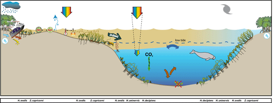
These habitats are also closely associated with mangrove forests, characterised by fine sediments and prone to high sedimentation and anoxic conditions. The physical and biological connectivity between these habitats is of high importance to support the detrital food chains and the productive faunal communities. The dominant influence of estuary habitats is terrigenous runoff from seasonal rains. Increased river/creek flow results in higher sediment loads which combine with reduced light to create potential light limitation for seagrass (McKenzie 1994). Estuary habitats also have higher loadings of micro and macro-algal epiphytes than those in other seagrass habitats. Salinity fluctuations and scouring make estuary and inlet habitats a seasonally extreme environment for seagrass growth. Estuary habitats also include the ports and shipping activities (including dredging).
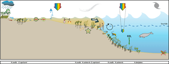
Shallow unstable sediment, fluctuating temperature, and variable salinity in intertidal regions characterize these habitats. Physical disturbance from waves and swell and associated sediment movement primarily control seagrass growing in these habitats.
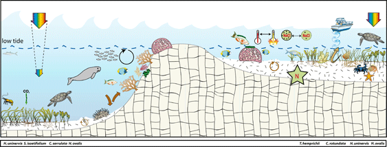
Reef seagrass habitats in the region are often adjacent to areas of high tourism use and boating activity with propeller and anchor scarring impacts. Globally, nutrient concentrations are generally low in reef habitats due to the coarse nature of the sediments coral sand. In these types of carbonate sediments the primary limiting nutrient for seagrass growth is generally phosphate. This is due to the sequestering of phosphate by calcium carbonate sediments. In this region seagrass meadows inhabiting the near shore inner reefs and fringing reefs of coastal islands inhabit a mixture of terrigenous and carbonate sediments, such as Green Island. Seagrasses at this location have been shown to be nitrogen limited (Udy et al. 1999)
Marine Monitoring Program
2019 -2020 Summary
Seagrass meadows within the Wet Tropics showed an overall decline in the seagrass condition index in 2019–20, and remain in a vulnerable state, particularly in the southern sub-region. Seagrass condition in the north decreased to poor following on from the highest score ever recorded for the region in 2018–19. By contrast, seagrass condition improved slightly, but remained poor in the south. The combined regional condition was Poor.
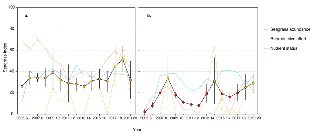
An examination of temporal trends in seagrass abundance across the region shows a high degree of variability reflecting a complex range of environmental and biological processes.
In the northern Wet Tropics sites, seagrass abundance decreased slightly in 2019–20 relative to the previous period because of declining trends at two intertidal reef sites, despite mild conditions across the sub-region.
In the south, seagrass abundance is on an increasing trajectory on average, although the seagrass abundance score decreased slightly in 2019–20. Abundance is low compared to the north, and abundances have significantly declined over the long-term at intertidal sites. The declines are a legacy of losses that occurred from 2009 to 2011, the result of multiple years of above-average rainfall and severe weather. Recovery of seagrass meadows post 2011 has been challenged, particularly in the south, by unstable substrates, chronic poor water quality compared to the north (high turbidity, light limitation) and limited recruitment capacity.
Coastal habitats in the north have maintained a healthy seed bank, and in 2019–20 seed density was the second highest on record. Reproductive effort was low at coast and reef intertidal sites signalling a potential future decline in seeds, but high at reef subtidal sites. In the south, reproductive effort was the third and second highest on record at intertidal and subtidal sites respectively, but sexual reproduction remained absent in coastal habitat. There were no seeds recorded in the south, as is typical for the sub-region. The absence of sexual propagules indicates low resilience is likely a contributor to slow recovery in the sub-region.
Leaf tissue nutrients (C:N) have remained relatively unchanged in the north for a number of years, and suggest an excess of nitrogen relative to photosynthetic C uptake (C:N <20), which is consistent with the high frequency of exposure to secondary water particularly in coastal habitat. Nutrient status therefore remained poor. In the south, the nutrient status indicator increased slightly at reef sites, resulting in the 2019–20 score increasing, but remaining poor.
THE NORTHERN WET TROPICS
SEAGRASS STATUS 2019-2020 20
In the northern Wet Tropics, the seagrass condition index dropped to a poor rating in 2019–20 following the highest score (in 2018–19) since reporting was established. Similar to the overall NRM regional grade, the decline was primarily due to reduced reproductive effort and reduced abundance scores.
The seagrass abundance score has progressively declined since 2017–18, but remains graded as moderate in 2019–20.
Inshore seagrass and habitat condition: 20
- The long-term trend in seagrass percent cover is variable between monitoring locations, but closely reflects the sub-regional scores with improved cover from 2014–15.
- Reproductive effort has fluctuated the most of the three condition indicators, and in 2019–20 was rated very poor, after reaching the highest score since monitoring was established in 2018–19. Due to the variable nature of sexual reproduction in seagrass systems, no long term trends are apparent.
- In contrast, seagrass leaf nutrient (C:N) status has varied the least of all indicators, and although declined marginally in 2019–20, has remained in a poor grade.
Seagrass abundance, composition and extent: 20
- In the northern Wet Tropics, seagrass abundance over the long-term is higher at intertidal reef (28.3 ±2.1 %) than subtidal reef (17.1 ±2.4 %) or coastal habitats (14.8 ±1.6 %). In 2019–20, although seagrass abundances remained steady at 4 of the 7 sites assessed, with the increase in abundance observed at only one site, offset by declines experienced at the remaining sites, resulting in a decrease in abundance overall.
- Although seagrass losses have occurred at the local level (e.g. individual sites) for some period over the duration of the monitoring, complete loss has not occurred at the habitat level. Nevertheless, abundance has fluctuated between and within years. For example, seagrass cover at coastal habitats differs between seasons (9.5 ±1.3 % in the dry and 19.8 ±2.1 % in the late dry-monsoon) and years (from 3.9 to 24.9 % annual average).
- In the northern Wet Tropics, changes in seagrass abundance were variable among habitats, with 2 of the 7 of sites significantly declining over the long-term, while no trend was apparent for the remaining sites.
Seagrass reproductive status: 20
- In the northern Wet Tropics, reproductive effort declined sharply after it peaked during 2018–19 in coastal intertidal habitats (Yule Point). Reproductive effort was depressed in reef intertidal habitats, but increased to the third highest level on record in reef subtidal habitats. Seed density was the second highest on record at coastal intertidal habitats, likely a consequence of high reproductive effort in the previous year. To date, seed banks have remained very low across the region in reef habitat (Figure 45). Some possible explanations for the low seed bank include failure to set seed, particularly in low density dioecious species, or rapid loss of seeds after release from germination or grazing.
Epiphytes and macroalgae: 20
- Epiphyte cover remained above the overall inshore Reef long-term average across in the wet season in all habitats in the northern Wet Tropics in 2019–20 , but below average in reef habitats during the dry season.
- Macroalgae cover was lower than the Reef long-term average in coastal habitat and reef subtidal habitats in both the wet and dry season. Macroalgae cover was higher than the Reef long-term average in reef intertidal habitats, as is typical for the habitat because it attaches to coral rubble.
CLIMATE AND ENVIRONMENTAL PRESSURES 2019-2020 20
Environmental conditions were relatively benign in 2019–20 across the northern Wet Tropics compared to the long-term average.
- No tropical cyclones affected the region during the period.
- Annual rainfall and river discharge were lower than average in each catchment and river entering the region.
- Sites were primarily exposed to ‘green’ water, which allows more light to reach the seagrass habitats than ‘brown’ water21
- Daily tide exposure in the north was below the long‐term average for the third consecutive year, which may have provided some respite from the elevated temperatures, particularly in coastal habitats.

Location
Low Isles
Monitoring: ongoing (MMP)
Principal watchers: Seagrass-Watch HQ
Location: approximately 15km off the coast of Port Douglas.
Site codes: LI1, LI2 (subtidal)
Issues: land runoff & boat traffic
Comments: popular recreational area and turtle feeding grounds
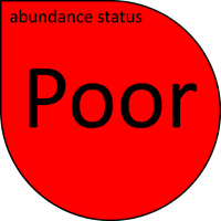
- seagrass abundance declined over the last year at both intertidal and subtidal sites, with abundances significantly lower in 2020 than 2019. Overall, seagrass abundance is in a Poor state
- both sites remain dominated by the colonising species Halophila ovalis, with a minor increase in Thalassia hemprichii intertidally
- seagrass canopy height had been gradually increasing since 2014, but dramatically declined in mid 2021.
Seagrass cover, species composition and canopy height
Seagrass Cover: Timeseries of seagrass cover. Mean and standard error of site level observations shown. Timing of impacts attributed to acute disturbance events (Tropical cyclones) are indicated by vertical lines and disturbance symbol ֎ . Lower case "s" after site code, denotes subtidal sites.
Seagrass Composition: Mean composition of each seagrass species during each sampling event.
Plots are interactive with mouse-over features providing additional detail.
Location
Yule Point
Monitoring: ongoing (MMP)
Principal watchers: Seagrass-Watch HQ
Location: coastal intertidal sand banks, protected by an extensive fringing reef
Site codes: YP1, YP2
Issues: Storm water & land runoff
Comments: The seagrass meadows at Yule Point are located on naturally dynamic intertidal sand banks. These meadows are dominated by Halodule uninervis with some Halophila ovalis. A small patch of Zostera muelleri was present closer inshore, however it was lost in 2011. The meadows at Yule Point are often exposed to regular periods of disturbance from wave action and consequent sediment movement. The sediments are relatively unstable restricting seagrass growth and distribution. The meadows are also popular dugong feeding grounds, and grazing trails are abundant.
- Seagrass abundance appears to follow typical season pattern (higher in late spring-summer than winter). Sites are dominated by Halodule uninervis and Halophila ovalis.
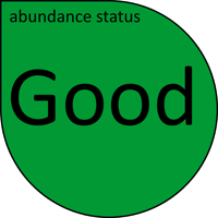
- Seagrass abundance relative to the seagrass guidelines indicates that the seagrass meadows at Yule Point have remained in a Good state since 2015.
- Although the seagrass abundance and meadow extent has fluctuated over the last two decade, sites today appear similar to 1967, when den Hartog (1970) photographed the area and described the species present and sediment condition.
- The proportion of Halophila ovalis fluctuates over time. Periods of higher proportions indicate higher levels of physical disturbance (e.g., sediment movement) .
- Seagrass canopy height shows a clear season pattern – correlating with abundance of Halodule uninervis.
- Canopy height is slightly higher at YP2 than YP1.
- Epiphyte cover on seagrass leaves has fluctuated greatly over the last two decades, with no apparent long-term trend.
- Macroalgae generally increase in spring/early summer, but has remained well blow the GBR long-term average for coastal habitats since 2006.
- A persistent seed bank occurs at Yule Point, and in 2019–20 seed density was the second highest on record.
Seagrass cover, species composition and canopy height
Seagrass Cover: Timeseries of seagrass cover. Mean and standard error of site level observations shown. Timing of impacts attributed to acute disturbance events (Tropical cyclones) are indicated by vertical lines and disturbance symbol ֎ .
Seagrass Composition: Mean composition of each seagrass species during each sampling event.
Plots are interactive with mouse-over features providing additional detail.
Location
Ellie Point
Monitoring: suspended
Past watchers: Tom Collis and Seagrass-Watch HQ
Location: on the north of Cairns Harbour, adjacent to the mouth of the Barron River
Site code: EL1
Issues: Land runoff & boat traffic
Comments: Popular recreational fishing area and turtle feeding grounds
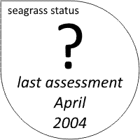
Status (April 2004):
- Site was last examined on 6 April 2004.
- Site appeared to display a typical seasonal pattern of seagrass abundance (higher in late spring-summer than winter).
- Site was dominated by Zostera muelleri with Halodule uninervis and Halophila ovalis;
- Site appeared to be recovering in extent and abundance since the substantial loss of seagrass area and abundance reported in December 200121.
- Results of monitoring indicated that seagrasses at Ellie Point appear relatively healthy and that there had been an overall increase from values recorded in February 2002.
Seagrass cover and species composition
Location
Green Island
Monitoring: ongoing (MMP)
Principal watchers: Seagrass-Watch HQ
Location: reef-platform on Great Barrier Reef mid shelf reef approximately 27 km north east of Cairns
Site codes: GI1, GI2, GI3 (subtidal)

Issues: Elevated nutrients and land runoff
Comments: Green Island is a vegetated sand cay approximately 12 ha in area with a maximum elevation of 4.5m. There are extensive seagrass meadows on the reef flat and in the waters surrounding Green Island, covering an area of 152 hectares with at least 9 species (Cymodocea rotundata, Cymodocea serrulata, Halodule uninervis, Halophila capricorni, Halophila decipiens, Halophila ovalis, Halophila spinulosa, Syringodium isoetifolium, and Thalassia hemprichii) identified.
The distribution of seagrass around Green Island has changed substantially in the last 50 years, possibly from poor water quality, a consequence of increases in tourist visitation and increased nutrients emanating from the island’s sewage outfall (the island’s treatment facility was upgraded to tertiary in the early 1990’s) 1.
The most dramatic change however, has been the seagrass species composition, with the species Syringodium isoetifolium now dominating most of the lagoon meadows; the expansion found to be clearly influenced by cumulative impacts and chronic small-scale physical disturbances2. Green Island is a green (no fishing) zone of the GBRMP, and a dugong and turtle feeding ground.
- Seagrass abundance follows a typical season pattern (higher in late spring-summer than winter).
- Seagrass abundance relative to the seagrass guidelines indicates that the seagrass meadows at Green Island are in a Good state.
- Prior to July 2018, seagrass abundance has increased slightly over the previous 12 months at both sites. The July 2018 decline is likely a consequence of seasonal low (secenscence) during the cooler months.
- Sites are dominated by Cymodocea rotundata, Thalassia hemprichii, Halodule uninervis and Halophila ovalis.
- Seagrass species composition appears to fluctuate throughout the year, however no long-term trend is apparent.
- Seagrass canopy height is generally higher at GI1 than GI2.
- Macro-algae at Green Island is predominately composed of Halimeda spp. and abundance generally increases in spring/early summer. Mean abundance is higher at GI1 than GI2, and currently at or below the GBR long-term average (red line in graphs).
- Epiphyte cover on seagrass leaf blades at Green Island sites has varied greatly over the years, and is currently below the GBR long-term average for reef habitats.
- No Halodule seeds have found at Green Island meadows.
Seagrass cover, species composition and canopy height
Seagrass Cover: Timeseries of seagrass cover. Mean and standard error of site level observations shown. Timing of impacts attributed to acute disturbance events (Tropical cyclones) are indicated by vertical lines and disturbance symbol ֎ . Lower case "s" after site code, denotes subtidal sites.
Seagrass Composition: Mean composition of each seagrass species during each sampling event.
Plots are interactive with mouse-over features providing additional detail.
THE SOUTHERN WET TROPICS
The seagrass meadows in the region are influenced primarily by runoff from the Tully and Murray Rivers. Both of these rivers have been labeled as medium/high risk to inshore areas by the GBRMPA. Of the two rivers, the Tully is the largest with an annual discharge of 120,000 tonnes of fine sediment, 125 tonnes of phosphorus and 1,300 tonnes of nitrogen 3. Approximately 93% of seagrass meadows within the Tully marine area are inundated every year by primary flood plumes, exposing the seagrass to intermittently high sediment and high nutrient concentrations for periods of days to weeks and potentially high loads of particles settling on the plants and seafloor4. Besides sediments and nutrients, flood plumes may also contain herbicides (e.g., diuron). All monitoring sites are located within the modeled herbicide first flush plume zone for the Tully-Murray Rivers5 and diuron was reported from nearby seagrass meadows in 20066.
From December to March low seagrass abundance often coincides with high rainfall (between 800 and 2000 mm) and high loads of sediments and nutrients to nearshore marine waters. Agricultural (e.g. grazing, forestry and cropping) and urban developments are the primary land uses in coastal catchments and contribute high loads of nutrients and sediments to nearshore coastal waters. Sediments and nutrients decrease light availability for seagrass by reducing light penetration in the water column and promoting the growth of algae that can shade seagrass blades. Warm water temperatures during summer also promote growth of algae and can lower productivity of seagrass meadows. Coupled with physical disturbance from storm activity seagrass growth and abundance may therefore be severely depleted over the wet season. Seagrass meadows are generally most abundant in October-November following the dry season that has more favorable light and temperature conditions.
Monitoring of intertidal seagrass meadows occurs in two seagrass habitat types in the region: coastal and reef.
STATUS :20
At coastal habitats in Lugger Bay, complete loss was sustained for periods of years. Although recovery is very slow, isolated seagrass shoots appeared at Lugger Bay sites in 2016–17, and by 2018–19 small patches had established which have changed little in the following 12 months. Abundances similarly improved at the reef intertidal habitats, but remain well below historical levels.
In the southern sub-region, 2 of the 8 sites have significantly declined over the long-term, but these only occurred at the coastal intertidal sites (Lugger Bay). No long-term trend was apparent in the reef habitats of the southern sub-region.
The proportion of seagrass species displaying colonising traits varied across habitats. In the coastal intertidal habitat there have been cycles of changing species composition since the substrate at Lugger Bay was eroded in 2011 (caused by TC Yasi). Opportunistic species appear unable to establish enduring meadows, potentially due to light limitation associated with deepening of the habitat.
Colonising species become dominant following periodic decline of other species in what appears to be recalcitrant degradation. In 2019–20, the proportion of seagrass species displaying colonising traits decreased to zero at coastal intertidal habitats but based on recent historical change, is not expected to last. Colonising species remained in low proportions in all other habitats; a promising sign of recovering trajectories.
All southern Wet Tropics seagrass meadows were lost in early 2011 as a consequence of cyclone Yasi. Since then, intertidal reef meadows have progressively improved, with the greatest extent since 2011 measured in 2019–20. At intertidal coastal habitats, the meadows have not improved greatly, but a few isolated patches which colonised in mid-2018 appear to have established. The greatest fluctuation in extent has occurred in subtidal reef meadows, which established in 2014, but after rapidly expanding have sharply declined. In 2018–19, only a few small isolated patches of seagrass remained of the subtidal reef meadows.
Location
Dunk Island
Monitoring: biannual
Principal watchers: Seagrass-Watch HQ
Location: Monitoring occurs on the large reef-platform on the western side of the island. The sites are located on the intertidal bank between Pallon Beach and Kumboola Island, and on the subtidal meadow in Brammo Bay
Site codes: DI1, DI2, DI3 (subtidal)
Issues: agricultural runoff from adjacent rivers
Comments: Dunk Island is a continental island, 4 km offshore from Mission Beach. The Family Islands National Park covers 7.3 km² while an airstrip, resort and farm cover the remaining 2.4 km² in the north-west. The Indigenous Australian name for Dunk Island is Coonanglebah, “The island of peace and plenty.”
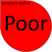
- seagrass abundance at Dunk Island remains in a Poor state
- seagrass cover is generally less than 20%, and peaked in late 2008/early 2009. Since mid 2009 abundance significantly declined and has remained low.
- on the 3rd February 2011, severe Tropical Cyclone Yasi (Category 5) passed directly over Dunk Island. Rated as one of the most powerful cyclones to have affected Queensland since records commenced, TC Yasi impacted the island with sustained winds of 205 km/h, gusting up to 285 km/h.
- erosion and sand movement over the intertidal banks from TC Yasi severely impacted the seagrass meadows. Only a few isolated shoots remain.
- prior to TC Yasi, a seasonal trend in abundance was present, with slightly higher abundance in the late dry season (Sep-Nov)
- prior to TC Yasi, Dunk Island sites were dominated by H. uninervis and C. rotundata with T. hemprichii/ H. ovalis and C. serrulata.
- post TC Yasi, only isolated shoots of Halodule uninervis are present scattered across the intertidal bank or in shallow sheltered pools
- seagrass tissue nutrient concentrations in the late dry 2009, indicated these sites were nutrient poor or reduced P pool
- epiphyte cover was variable and above the GBR long-term average for reef habitats. Macro-algae abundance was relatively stable, with mean covers less than 10%
- pre TC Yasi, the distribution of the meadow at Dunk Island had remained stable since monitoring was established
- post TC Yasi, no distinguishable meadow was present
- reproductive effort is poor and seed banks non existent. This suggests that seagrass meadows will take longer to recover following disturbance and may be at risk from repeated impacts.
Seagrass cover, species composition and canopy height
Seagrass Cover: Timeseries of seagrass cover. Mean and standard error of site level observations shown. Timing of impacts attributed to acute disturbance events (Tropical cyclones) are indicated by vertical lines and disturbance symbol ֎ . Lower case "s" after site code, denotes subtidal sites.
Seagrass Composition: Mean composition of each seagrass species during each sampling event.
Plots are interactive with mouse-over features providing additional detail.
Location
Lugger Bay
Monitoring activity: triennial
Principal watchers: Seagrass-Watch HQ
Location: South Mission Beach, on the northern section of the large intertidal sandbank within Lugger Bay
Site codes: LB1, LB2

Issues: agricultural runoff from adjacent rivers
Comments: Lugger Bay is a coastal habitat and the sites are located on naturally dynamic intertidal sand banks, protected by a fringing reef. These meadows are dominated by Halodule uninervis with some Halophila ovalis and are often exposed to regular periods of disturbance from wave action and consequent sediment movement. The sediments in these locations are relatively unstable restricting seagrass growth and distribution. The meadows are dugong feeding grounds, and grazing trails are often present.
- seagrass abundance at Lugger Bay is currently in a Poor state
- on the 3rd February 2011, severe Tropical Cyclone Yasi (Category 5) passed directly over South Mission Beach and Lugger Bay. Rated as one of the most powerful cyclones to have affected Queensland since records commenced, TC Yasi impacted the region with sustained winds of 205 km/h, gusting up to 285 km/h.
- erosion and sand movement over the intertidal banks from TC Yasi severely impacted the seagrass meadows. No plants were found within 100m of each site.
- prior to TC Yasi, seagrass cover was generally low (<10%) and similar to observations in the early 90’s at this location (Mellors et al. 2005).
- the decline of seagrass at Lugger Bay in 2006 appears a consequence of severe TC Larry, which crossed the coast 50km north of the location on 20 March 2006. In April 2008, the seagrass had recovered to 2005 abundances, but has since declined significantly.
- seagrass abundance at Lugger Bay is generally lower in the late monsoon and increases throughout the year until the monsoon
- the sites at Lugger Bay were monospecific Halodule uninervis meadows. Although Zostera capricorni was present at LB1 in late 2005, it was lost due to the impact of TC Larry in early 2006 and has not re-established.
- seagrass tissue nutrients in Lugger Bay indicate a nutrient rich environment where light may be limiting to growth
- the distribution of the seagrass meadow changed little throughout 2009, however significantly declined during the late monsoon and throughout 2010
- no seagrass meadows currently exist in Lugger Bay.
- reproductive effort is poor and seed banks non existent. This suggests that seagrass meadows will take longer to recover following disturbance and may be at risk from repeated impacts.
- that seagrass meadows will take longer to recover following disturbance and may be at risk from repeated impacts.
Seagrass cover, species composition and canopy height
Seagrass Cover: Timeseries of seagrass cover. Mean and standard error of site level observations shown. Timing of impacts attributed to acute disturbance events (Tropical cyclones) are indicated by vertical lines and disturbance symbol ֎ .
Seagrass Composition: Mean composition of each seagrass species during each sampling event.
Plots are interactive with mouse-over features providing additional detail.
Location
Goold Island
Monitoring: ad hoc
Principal watchers: Girringun Rangers, the Cardwell Indigenous Rangers Unit and Seagrass-Watch HQ
Location: the meadow is on the extensive reef flat meadow on the leeward side of the island.
Site codes: GO1
Issues: agricultural runoff from adjacent rivers
Comments: Goold Island is a small (8.3km2) continental island located 17 km offshore from Cardwell. The Island is a national park within the Great Barrier Reef World Heritage Area. The Bandjin and Girramay Aboriginal people are the Traditional Owners of Goold Island (traditionally know as Marrajumban). Traditional use of the island is well established and evidence of early Aboriginal occupation includes the large stone fish trap on the northern end of Western Beach, a large campsite, and some shell middens. The fish trap is one of the few lasting structures left by the former inhabitants in this area and indicates the lifestyle and the food sources used during Aboriginal occupation of the island. As well as the physical evidence of Aboriginal use, Goold Island, in common with many other areas, had cultural and spiritual significance to the Aboriginal people of the area, values which remain today for descendants of the original inhabitants.
Intertidal seagrass meadows are found on the fringing reef flats on the south western and southern shores of the island. The site is predominantly Cymodocea serrulata with some Halodule uninervis. Enhalus acoroides is also found within the meadow.
The site is being monitored as part of the turtle and dugong monitoring plan for Girringun Sea Country. Girringun traditional owners have also signed a formal agreement (TUMRA) that describes how traditional Owners wish to manage the use of their marine resources in the region. A Traditional Use of Marine Resources Agreement is accredited by the Great Barrier Reef Marine Park Authority (GBRMPA) and the Department of Environment & Resource Management/Queensland Parks and Wildlife (DERM/QPW). It recognises the special relationship that indigenous groups have with the Sea and its resources in relation to their culture, society, economy and well being. The agreement was developed by the six Girringun sea country groups: Djiru, Gulnay, Girramay, Bandjin, Warragamay and Nywaigi. It applies to the sea country between Rollingstone and Mission Beach and focuses on the sustainable harvest of marine resources using culturally appropriate methods. The sustainability of dugong and turtle populations within this region also relies on the condition and health of their major food source – seagrass.
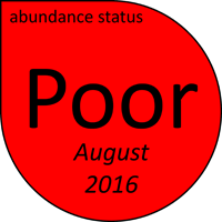
- seagrass abundance at Goold Island was in a Poor state when last assessed.
- In 2008 when the site was established, there was a lush meadow of Cymodocea serrulata with some Halodule uninervis, and Enhalus acoroides with around 45% cover. In 2009 the meadow significantly declined with only isolated Cymodocea serrulata shoots remaining.
- In September 2010, the meadow state changed, becoming dominated by the colonising Halophila ovalis. The meadow has remained in this state with a recent appearance of a few isolated Cymodocea serrulata seedlings.
- Dugong grazing trails have been observed in the meadow over the last 12 months.
Seagrass cover, species composition and canopy height
Location
Missionary Bay (Hinchinbrook Island)
Monitoring: ongoing
Principal watchers: QPWS
Location: subtidal sites
Site codes: MS1, MS2

Seagrass cover, species composition and Macroalgae
Seagrass Cover: Timeseries of seagrass cover. Mean and standard error of site level observations shown. Lower case "s" after site code, denotes subtidal sites.
Seagrass Composition: Mean composition of each seagrass species during each sampling event.
Plots are interactive with mouse-over features providing additional detail.