Papua New Guinea
Papua New Guinea (PNG) occupies the eastern half of the rugged tropical island of New Guinea (which it shares with the Indonesian territory of Irian Jaya) as well as numerous smaller islands and atolls in the Pacific.
The central part of the island rises into a wide ridge of mountains known as the Highlands, a territory that is so densely forested and topographically forbidding that the island’s local peoples remained isolated from each other for millennia.
The coastline is liberally endowed with spectacular coral reefs, giving the country an international reputation for SCUBA diving. The smaller island groups of Papua New Guinea include the Bismarck Archipelago, New Britain, New Ireland and the North Solomons. Some of these islands are volcanic, with dramatic mountain ranges, and all are relatively undeveloped.
It is generally agreed that there are 13 seagrass species present in PNG. Seagrass communities in PNG grow on fringing reefs, in protected bays and on the protected side of barrier reefs and islands. Seagrass meadows are a significant feature at several regions in PNG (eg. Manus Island, Wewack, Port Moresby, Milne Bay province and the Tigak Islands and Kavieng) and scattered areas of seagrasses line much of the coastline of NG mainland (eg. Madang, Morobe and Western provinces).
Extensive mixed seagrass meadows are the dominant community type in the bays, harbours and sheltered capes along the coasts of the NG mainland and the islands of New Britian and New Ireland. These extensive seagrass meadows are dominated by T. hemprichii and/or E. acoroides, with up to another 10 species present to varying degrees.
The total area of seagrass meadows in PNG is unknown, as no broad scale mapping exercise has been conducted. The major changes in PNG seagrass meadows would have occurred post World War Two and are related to coastal development, agricultural land use, or population growth. In general though there is insufficient information and no long-term studies from which to draw direct conclusions on historic trends.
These localised impacts are likely to be from soil erosion related to coastal agriculture (eg palm oil plantations), land clearing (eg logging and mining), bush fires and from the discharge of mine tailings. Other effects include sewage discharge, industrial pollution and overfishing. Most of these impacts can be managed with appropriate environmental guidelines, however climate change and associated increase in storm activity, water temperature and/or sea level rise has the potential to damage seagrasses in the region or to influence their distribution. Sea level rise and increased storm activity could lead to large seagrasses losses.
Seagrass-Watch in Papua New Guinea
To provide an early warning of change, long-term monitoring has been established in PNG as part of the Seagrass-Watch, Global Seagrass Observing Network(www.seagrasswatch.org). Establishing a network of monitoring sites in PNG provides valuable information on temporal trends in the health status of seagrass meadows in the region and provides a tool for decision-makers in adopting protective measures. It encourages local communities to become involved in seagrass management and protection. Working with both scientists and local stakeholders, this approach is designed to draw attention to the many local anthropogenic impacts on seagrass meadows which degrade coastal ecosystems and decrease their yield of natural resources.
 | McKenzie, L.J., Yoshida, R.L., Aini, J.W., Andréfouet, S., Colin, P.L., Cullen-Unsworth, L.C., Hughes, A.T., Payri, C.E., Rota, M., Shaw, C., Tsuda, R.T., Vuki, V.C. and Unsworth, R.K.F. (2021). Seagrass ecosystems of the Pacific Island Countries and Territories: a global bright spot. Marine Pollution Bulletin 167, 112308. doi.org/10.1016/j.marpolbul.2021.112308 |
Location
Kavieng
Monitoring: Suspended
Principal watchers: John Aini (Ailan Awareness), Kavieng Fisheries College, Bol villagers and Lavongai villagers.
Occasional and past watchers: Seagrass-Watch HQ
Location:Lavongai (New Hanover), Panapai (New Ireland), Panamecho (New Ireland)
Site code: BL1, LV1, LV2, PA1, PO1
Issues: sewage, chemical spills, land runoff
Comments: Seagrass meadows within Madang Lagoon are limited to the narrow intertidal fringing reefs. The slope from the reef crest is relatively steep to deep waters, which provides very little space or opportunity for seagrass to establish. High tidal currents in the region, also limit seagrass meadows to protected bays.
Status (December 2008):
- Monitoring has been suspended since July 2003
- There appeared to be little change in abundance and species composition between monitoring events.
- Sites were dominated by Thalassia hemprichii and Cymodocea rotundata
- Male flowers was observed at Panamecho in July 2003, with significant amounts floating on the water surface during low spring tide.
- Insufficient data to describe long-term trends, or comment on current status.

Seagrass cover, species composition
Interactive plots with mouse-over features providing additional detail
Seagrass cover, species composition
Interactive plots with mouse-over features providing additional detail
Seagrass cover, species composition
Interactive plots with mouse-over features providing additional detail
Location
Madang
Monitoring: Suspended
Principal watchers: WWF South Pacific Programme
Occasional and past watchers: Seagrass-Watch HQ
Location:Damasa Island and Simosle near Riwo village on the western shores of Madang Lagoon
Site code: DM1, SM1
Issues: Sewage, coastal development, land/plantation runoff
Comments: Sites were chosen in the near vicinity of Kavieng. All sites located on intertidal fringing reefs with a mixture of Halodule uninervi, Enhalus acoroides, Thalassia hemprichii, Cymodocea rotundata and Halophila ovalis.

Status (December 2008):
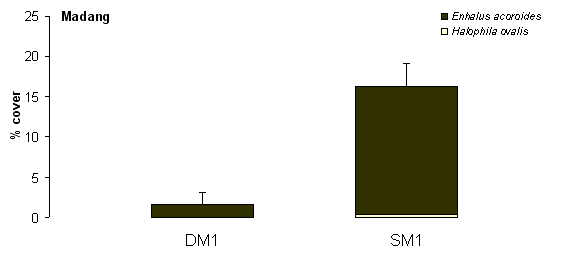
- Insufficient data to comment on condition or current status.
- Sites in Madang lagoon were dominated by Enhalus acoroides, with small isolated patches of Halophila ovalis.
- Sites were only sampled in July 2003.

Location
Bootless Inlet
Monitoring: Suspended
Principal watchers: Motupore Island Research Centre
Occasional and past watchers: Seagrass-Watch HQ, University of PNG & University of Goroka, PNG National Fisheries Authority, WWF and WCS
Location:BT1 and BT2 are located on the reef flat of Motupore island – a small island within Bootless Bay/Inlet, approximately 15km SE of Port Moresby. BT3 is located on the reef flat at Taurama.
Site code: BT1, BT2, BT3
Issues: Sewage, coastal development, land/plantation runoff
Comments: The island is virtually surrounded by seagrass meadows, as extensive fringing reefs are prominent on the southern and western side of the island. Motupore Island has been the site of several seagrass research projects in the 1970’s/80’s. The work conducted there were some of the earliest research on tropical seagrasses including zonation , the relationship between leaf shape and water depth, epiphytes and growth. Growth studies on Enhalus acoroides conducted at the island in 1976, reported maximum leaf growth rates of 2.33cm per day in November/December. Motupore Island has 10 species of seagrass.
A new site was established on the eastern corner of reef flat in front Taurama (BT3) in mid 2008.

Status (December 2008):
- Sites appear to be showing a fairly typical seasonal pattern of seagrass abundance (higher in late spring-summer than winter).
- Overall seagrass abundance has remained stable since monitoring was extablished.
- Site dominated by Cymodocea rotundata and Thalassia hemprichii with Enhalus acoroides, Syringodium isoetifolium and other species in minor amounts.
- Macro-algae abundances generally low (<10%)