micronesia
Federated States of Micronesia
The Federated States of Micronesia (FSM) is a grouping of 607 small islands in the Western Pacific about 2,500 miles southwest of Hawaii, lying just above the Equator. It occupies more than one million square miles of the Pacific Ocean, and ranges 1,700 miles from East (Kosrae) to West (Yap). Each of the four States centers around one or more “high islands,” and all but Kosrae include numerous atolls.
The Federated States of Micronesia are made up of four island groups – Yap, Chuuk, Pohnpei and Kosrae – located in the eastern half of the Pacific Ocean.
Pohnpei occupies nearly half the country’s land area, with the rest almost equally divided between the other three states. The islands of Pohnpei, Kosrae and Chuuk are high volcanic islands, while Yap is a raised part of the Asian continental shelf.
There’s a wide range of hard and soft corals, anemones, sponges, whales, porpoises and shellfish, including the giant tridacna clam. A few species of sea turtle lay their eggs on the local beaches, and the islanders use both turtles and eggs for food. The islands are also aflutter with more than 200 species of birds.
Eight species of seagrasses are confirmed from the FSM with diversity attenuating eastward .
Seven species, except Thalassodendron ciliatum, are present in Yap State and six species except Cymodocea serrulata and Halophila gaudichaudii are present in Chuuk State. Thalassodendron ciliatum has been reported from Gray Feather Bank, a submerged atoll in Chuuk State.
Only three species (Thalassia hemprichii, Enhalus acoroides and Cymodocea rotundata) are present in Pohnpei and Kosrae States. Most seagrass occurs in water <3 m deep, and meadows can be monospecific or consisting of multispecies communities, with up to 3 species present at a single location1.
Seagrass-Watch in Micronesia
To provide an early warning of change, long-term monitoring has been established in Micronesia as part of the Seagrass-Watch, Global Seagrass Observing Network (www.seagrasswatch.org). Establishing a network of monitoring sites in Micronesia provides valuable information on temporal trends in the health status of seagrass meadows in the region and provides a tool for decision-makers in adopting protective measures. It encourages local communities to become involved in seagrass management and protection. Working with both scientists and local stakeholders, this approach is designed to draw attention to the many local anthropogenic impacts on seagrass meadows which degrade coastal ecosystems and decrease their yield of natural resources.
 | McKenzie, L.J., Yoshida, R.L., Aini, J.W., Andréfouet, S., Colin, P.L., Cullen-Unsworth, L.C., Hughes, A.T., Payri, C.E., Rota, M., Shaw, C., Tsuda, R.T., Vuki, V.C. and Unsworth, R.K.F. (2021). Seagrass ecosystems of the Pacific Island Countries and Territories: a global bright spot. Marine Pollution Bulletin 167, 112308. doi.org/10.1016/j.marpolbul.2021.112308 |
Location
Kosrae
Monitoring: Archived
Past watchers: College of Micronesia and Pohnpei Conservation Society
Location: South eastern coast of the island, at the ancient city of Nan Madol. The site is accessible by car and a short walk to the reef flat where water pools at low tide.
Site code: NM1, NM2
Issues: Boat traffic
Comments: Pohnpei is a large island by FSM standards (approximately 24 km long and 20 km wide) with a complex fringing reef system

The island is mountainous and approximately 20 kilometres long and 12 kilometres wide. Monitoring sites are on the intertidal reef flat. Species of seagrass found were Enhalus acoroides, Thalassia hemprichii and Cymodocea rotundata.
A detailed assessment of Kosrae reef environments in 1989 found large dense meadows of Enhalus acoroides, Thalassia hemprichii and Cymodocea rotundata adjacent to Lelu Harbour. Over the last 3-4 decades there has been considerable coastal construction activity on the islands to build modern transportation facilities, and the seagrass meadows and reef flats have been severely impacted.
In the late 1960’s and early 1970’s, a runway was constructed between Kosrae and Lelu islands and the causeway construction had adverse effects on Lelu Harbour. The runway and associated causeways were constructed on the only available flat area on the island the reef flat. The original causeway blocked the water circulation and fish runs into inner Lelu Harbour, leading to a decline in seagrasses and fish catches. Fill for the runway expansion further reduced water circulation, fish yields, water quality and seagrasses in the harbour. Although the runway has since been abandoned with the construction of the new runway on the reef flat at Okat Harbour in the mid 1980s, the environmental effects of these constructions are possibly still impacting on the nearshore areas with shore erosion, reduced water flow and restoration by revetment still occurring at Lelu Harbour.
Seagrass-Watch monitoring will hopefully provide information on the condition and trends in the seagrass meadows on the reef flat of the harbour.
- Sites are similar in species composition and abundance.
- Each site had only been sampled once.
- Insufficient data to describe long-term trends
Seagrass cover, species composition and canopy height
Interactive plots with mouse-over features providing additional detail
Location
Pohnpei
Monitoring: Archived
Past watchers: Fisheries Development Division
Location: Sites KI1 & KI2 are established at Kisacs (Tafansak Village), on the north of Kosrae Island. Another site (KI4) is opposite the Nautilus Resort on the reef flat adjacent to Lelu Harbour.
Site code: KI1, KI2, KI4
Issues: Costal development, sewage effluent and land runoff.
Comments: The site is adjacent to a village and supported by the local schools and Kosrae Fisheries.

Seagrasses in Pohnpei are generally found in shallow water, less than 3 m deep. Extensive mixed species seagrass meadows are the dominant community type in the bays, harbours and on the fringing reef platforms of Pohnpei. These extensive seagrass meadows are dominated by the colonizing and intermediate species, such as T. hemprichii and/or C. rotundata, which can survive a moderate level of disturbance. They can also be found colonizing muddy substrates, particularly where water pools at low tide. Meadows of E. acoroides occur in shallow lagoons and border the gentle sloping mangrove fringes in the more protected bays as it has low resistance to perturbation.
The Seagrass-Watch sites are on either side of the now permeable remnants of an ancient causeway at Nan Madol, constructed 500 to 700 years ago. The sites are interesting as the shoreward site has greater seagrass cover, canopy height, algal abundance, and epiphyte abundance and lower species diversity (both seagrass and macro-algae) as well as muddier sediments than the seaward site. On the seaward site (NM1), average epiphyte cover was less than one tenth the epiphyte cover of that on the shoreward side (NM2). Cymodocea rotundata was the dominant seagrass species on the seaward site but was absent on the shoreward site, which was dominated by Thalassia hemprichii and Enhalus acoroides. The comparison of sites demonstrates that the effects of even this simple permeable barrier on seagrass meadows are evident and include differences in seagrass species, algal species, and fauna. Such information from this historic location provides an interesting basis for discussion on the effects of present-day Pacific Island causeway developments.
- Sites have only been examined on 2 occasions, where no change was detectable in seagrass composition or abundance.
- Insufficient data to describe long-term trends.
- Ongoing monitoring is dependent on the co-operation of the College of Micronesia and the Conservation Society of Pohnpei (CSP) with local communities.
Seagrass cover, species composition and canopy height
Interactive plots with mouse-over features providing additional detail
Palau
The Palau Islands group lies at the far western end of Micronesia in the Philippine Sea. A tightly bunched archipelago, Palau consists of the high islands of Babeldaob, Koror, Peleliu and Angaur; the low coral atolls of Kayangel and Ngeruangel; and the limestone Rock Islands, of which there are more than 200. Nearly all of the islands in the group sit inside a single barrier reef. The nation’s boundaries also encompass six small, isolated islands, collectively called the South-West Islands, which extend some 370 miles (600km) to the southwest, almost as far as Indonesia.
The region’s spectacular underwater biodiversity includes over 1500 species of fish and 700 species of coral and anemone. Other noteworthy sightings include giant tridacna clams, sea turtles, manta rays, gray reef sharks, sea snakes, chamber nautiluses and dugongs (manatees). On and near the land, there are massive reptiles, including estuarine crocodiles and monitor lizards. In addition, expect to see dozens of species of birds, colonies of fruit bats (the only native land mammals) on the Rock Islands, monkeys on Angaur, a few non venomous snakes and small lizards and more insects than you ever thought possible. There are no poisonous land animals on any of the islands.
In the Republic of Palau, long-term monitoring sites were established in the Rock Islands. The Rock Islands are part of a marine park/reserve The parks distance from urban development and agricultural land-use suggests no obvious impacts from catchment activities.
The information collected will complement existing coral reef monitoring programs inside and outside marine protected areas. The site is monitored by scientific and education staff from the Palau International Coral Reef Centre with the assistance of students from Palau College and members of the Palau Conservation Society.
A total of 10 seagrass species to occur in Palau . The most common seagrass species are Enhalus acoroides, Thalassia hemprichii, Halophila ovalis, Halodule uninervis,Syringodium isoetifolium, and Cymodocea rotundata. Halodule pinifolia occurs on intertidal sand flats along the east coast of Babeldaob and throughout the rock island sandy shallows. Halophila gaudichaudii is uncommon, and has only been reported from Ngermeduu Bay.
Intertidal meadows in Palau occur from both protected lagoon and inshore waters, to exposed fringing reef flats. Shallow subtidal meadows occur in many
locations, some from sheltered areas which are known to have persisted for decades, while others appear to have been of relatively recent (decade level) origin. The most extensive seagrass meadow in Palau is dominated by Enhalus acoroides and Thalassia hemprichii, and found within the lagoon north of Peleliu Island covering roughly 7 km2.
There are also large areas of shallow subtidal flats in the Rock Islands and on the periphery of Babeldaob with mixed seagrass and coral/algal communities. Seagrasses are rare on outer reef slopes; the main exception to this generality are the few areas with only a sediment slope (“sand falls”) where species of Halophila occur to 30–35 m depth.
The deepest lagoon bottoms (35–60 m depth), found in the northern lagoon (within the main reef complex) and at Velasco Reef, often have dense beds of macroalgae, but appear to lack seagrasses. Thalassodendron ciliatum occurs as isolated patches on the eastern fringing reef of Babeldaob, at few locations on the inside edge of the barrier reef at Kayangel Atoll and most abundantly as deep (15–25 m) eroding meadows on the sunken atoll rim of Velasco Reef, particularly at its the northern end. These deep meadows are largely unknown globally; only other similar records in PICTs come from reports from Gray Feather Bank(Chuuk, FSM)1.
Location
Betikl (Rock Islands)
Monitoring: Archived
Principal watchers: Palau International Coral Reef Centre
Location: The sites are located 10 km from Koror in the Rock Islands, and require access by boat
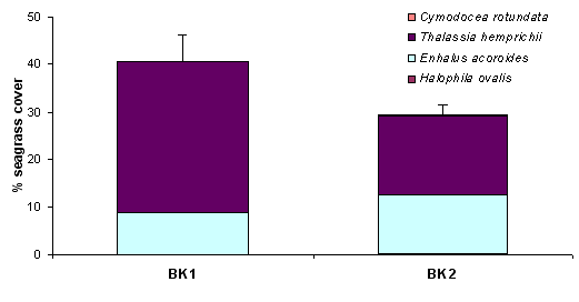
Site code: BK1, BK2
Comments: The Rock Islands are part of a marine park/reserve and their distance from urban development and agricultural land use suggests no obvious impacts from catchment activities. Ongoing coordination of monitoring by scientific and education staff from the Coral Reef Centre with the assistance of students from Palau Conservation Society and members of the Palau Conservation Society will be critical to ongoing monitoring efforts.

- The species composition of seagrass meadows here consists of the same suite of species found near the island of Koror, – Enhalus acoroides, Thalassia hemprichi, Cymodocea rotundata and Halophila ovalis.
- Site were not significantly different in abundance or species composition
- Each site has only been sampled once, in June 2002.
- Although current information is limited, anecdotal reports are that the seagrass meadows in Betikl are in a fair condition, and no major losses are apparent.
- Insufficient data to describe long-term trends or current condition.
