Seagrass Ecosystem INTERTIDAL FIELD RESOURCES
Intertidal Monitoring
WHAT IS MONITORING?
Monitoring is the repeated observation of a system, usually to detect change. Environment monitoring programs provide coastal management agencies with data to make evidenced-based decisions and policy.
Each Seagrass monitoring event usually takes about two hours to complete, once you have become familiar with the methods.
When starting your seagrass monitoring, we recommend four monitoring events in the first year (every 3 months) to provide an understanding of seagrass seasonality.
How frequent your monitor your seagrass site, is at the discretion and capacity of participants.
For long-term seagrass monitoring, we recommend monitoring at least once a year, around the same time each year.
The recommendation for sampling replicates sites within a location is that sites be sampled no longer than a maximum of 2 weeks apart. Any longer would risk compromising the data.
SEAGRASS MONITORING STRATEGIES
Seagrass-Watch has several seagrass monitoring strategies depending on the type and location of seagrass meadows. Below we describe the most popular method (Permanent Transects).
PERMANENT TRANSECTS
The use of Permanent Transects for monitoring, is a strategy developed by Seagrass-Watch and is commonly used in representative inter tidal meadows larger than 50m x 50m (e.g. 5.5 hectares).
A sentinel site (Permanent Transect sites) is 50m x 50m area within a homogeneous section of meadow. At each site, three parallel 50m transects (each 25m apart) are established. We advocate, “permanently” marking the site using a GPS to record points at the start and end of each transect. If you must physically mark the site, generally only the middle transect is permanently pegged/marked.
The location of sites is recorded by GPS. The seagrass along each transect are sampled by visual observation. At each transect, eleven quadrats are sampled (1 quadrat every 5m), every sampling event. All quadrats sampled are photographed to ensure standardisation/calibration of observers and to provide a permanent record.
Lay out and peg down the three 50 transects parallel to each other, 25m apart and orientated perpendicular to shore (heading out to sea or deeper water). Within each of the quadrats placed for sampling, complete the following steps:
- Step 1. Take a Photograph of the quadrat
- Step 2. Describe sediment composition
- Step 3. Describe other features and ID/count of macrofauna
- Step 4. Estimate seagrass percent cover
- Step 5. Estimate seagrass species composition
- Step 6. Measure canopy height (cm)
- Step 7. Estimate algae percent cover
- Step 8. Estimate epiphyte percent cover
- Step 9. Voucher specimen if required
- Step 10. Move to next quadrat
- Step 11. Completion of monitoring
- Photographs are taken at the every quadrat (0m-50m) along each transect.
- First place the photo quadrat labeller beside the quadrat with the correct code on it.
- Take the photograph from an angle as vertical as possible, which includes the entire quadrat frame, quadrat label and tape measure. Try to avoid having any shadows or patches of reflection off any water in the field of view. Tick the photo taken box on the datasheet for that quadrat. Please note: Camera should be set at the highest quality.
- To assess the sediment, dig your fingers into the top centimetre of the substrate and feel the texture.
- Describe the sediment, by noting the grain size in order of dominance (e.g., Sand, Fine sand, Fine sand/Mud).
- Please do not use descriptors like Sandymud, SandyMuddy, Muddysand etc
- Note and count any other features which may be of interest (eg. number of shellfish, sea cucumbers, sea urchins, evidence of turtle feeding), within the comments column.
- Count or estimate as best you can. Please do not use > or < symbols.
- If more than 50% of the quadrat is covered by water, measure and record the water depth in cm.
- Looking down on the quadrat from above, estimate the total percentage of the seabed (substrate) within the quadrat covered by seagrass. – use the percent cover photo standards as a guide.
- When estimating cover, estimate the footprint/shadow provided by the seagrass shoots
- Always use the percent cover photo standards (calibration sheets) as your guide
- Estimate cover as accurate as possible, e.g. 27%, 61%
- Identify the species of seagrass within the quadrat and determine the percent contribution of each species to the cover.
- When determining species composition for two or more species, always start with the least dominant.
- Use seagrass species identification keys provided.
- Use more than 1 feature to identify the species
- Total composition must equal 100%
- Measure canopy height of the dominant strap leaved species ignoring the tallest 20% of leaves.
- Measure from the sediment to the leaf tip of at least 3 mature leaf blades (strap leaved species).
- Write the 3 measures (cm) on the datasheet.
- Estimate % cover of algae in the quadrat.
- Algae are seaweeds that are not attached to seagrass but may cover or overlie the seagrass blades.
- Malcroalgae percentage cover is independent of seagrass cover, for example, you can have 100% seagrass and 100% algae (drift).
- Use “Algal percentage cover photo guide”.
- Epiphytes are algae attached to seagrass blades and often give the blade a furry appearance.
- First estimate how much of the blade surface is covered, and then how many of the blades in the quadat are covered (e.g., if 20% of the blades are each 50% covered by epiphytes, then quadrat epiphyte cover is 10%).
- Do not include epifauna with epiphytes. Epifauna are sessile animals attached to seagrass blades – please record % cover of epifauna in the comments or an unused/blank column – do not add to epiphyte cover.
- Use the epiphyte matrix to help you in the field. (DOWNLOAD: Epiphyte_matrix.pdf)
- Voucher specimens are only required if:
- establishing monitoring in a new region; a new seagrass species is present;
- or if you are unsure of the seagrass identification.
- Seagrass samples should be placed inside a labelled plastic bag with seawater and a waterproof label.
- Select a representative specimen of the species and ensure that you have all the plant part including the rhizomes and roots.
- Collect plants with fruits and flowers structures if possible.
- Voucher specimens are only required if:
- Repeat steps 1 to 8 for the remaining 32 quadrats
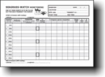
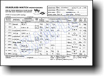
- Check data sheets are filled in fully.
- Ensure the full names of all observers (last name and first name), the date and site/quadrat details are clearly recorded on the datasheet.
- Also record the number of other observers assisting.
- Also record the GPS positions of the end of each transect.
- Remove equipment from site
- Remove all non-permanent pegs and roll up the tape measures. If the tape measures are covered in sand or mud, roll them back up in water.
- Wash & pack gear
- Rinse all tapes, pegs and quadrats with freshwater and let them dry.Review supplies for next quarterly sampling and request new materials
- Store gear for next quarterly sampling
- Press any voucher seagrass specimens if collected
- Submit your Data to Seagrass-Watch HQ
Data entry & Submission:
Region 5
(Tropical Indo-Pacific)
BIO REGION & EXCEL ENTRY
Once you have monitored your Seagrass-Watch site, you can now enter the data collected into a downloadable Microsoft Excel spreadsheet and submit it via email to admin@seagrasswatch.org
Prompt Data Submission:
We advocate a maximum 2 weeks post monitoring for data to be submitted.
Submitting data promptly provides an opportunity for feedback before the next sampling event.
- Step 1. Select your seagrass geographic bioregion
- Step 2. Save the spreadsheet file to your computer
- Step 3. Select the appropriate worksheet
- Step 4. Enter Observers/Date/Time etc
- Step 5. Enter Quadrat Observations
- Step 6. Repeat Steps
- Step 7. Submit Data to Seagrass-Watch HQ
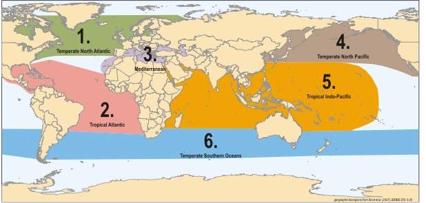
Download Region 5 web data entry spreadsheet
Region 5: Tropical Indo-Pacific (East Africa, south Asia and tropical Australia to the eastern Pacific)
- Save the spreadsheet file to your computer before you begin data entry. We suggest changing the file name to the site code and the sampling date.
- For example, if the site was Burrum Heads 1, and it was sampled on 09 February 2020 then the filename would be “BH1_09Feb20.xls“
- The spreadsheets are a similar layout to the standard datasheets.
- Each transect has it’s own worksheet.
- To select the appropriate worksheet, click on the tab at the bottom
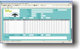
- To enter data, select each cell with your mouse.
- You can jump between cells by using the TAB button on your keyboard.
- First enter the FULL NAME (First and Last name) of the observers and the sampling date.
- Enter the location and site code.
- For the above example, the location is “Burrum Heads” and the site code is “BH1”.
- Enter the time you started sampling the transect and the time you finished. Times are entered at 24 hr with the hour separated from the minutes by a colon.
- For example. if the time was half past one in the afternoon, the time entered would be “13:30”.
- If you had a GPS (Global Positioning System) at the monitoring site, the latitude and longitude of the transect start
Enter the data for each quadrat
- Sediment: enter by the dominant grain size first, separating sediment categories by a forward slash. For example, if the quadrat was predominantly mud with some sand, then the data would be entered as “Mud/Sand”. Please do not use abbreviations “M/S” when entering into the spreadsheet.
- Comments: Enter information (including counts) of any features which may be of interest. For example, “sea cucumbers (x2), sea urchin (x1), evidence of turtle cropping”
- Photograph: type in “True” if you took a photo of the quadrat
- % cover: enter the total percent cover of seagrass within the quadrat
- % cover by species: enter the percentage cover that each species contributes to the total cover. For Species ID
- CR = Cymodocea rotundata
- CS = Cymodocea serrulata
- EA =Enhalus acoroides
- HC = Halophila capricorni
- HD = Halophila decipiens
- HM = Halophila minor
- HO = Halophila ovalis
- HP = Halodule pinifolia
- HS = Halophila spinulosa
- HT = Halophila tricostata
- HU = Halodule uninervis
- SI = Syringodium isoetifolium
- TC = Thalassodendron ciliatum
- TH = Thalassia hemprichii
- ZC = Zostera capricorni
Canopy: enter the three canopy heights of the dominant strap leaf species (the average will calculate automatically)
% Algae: enter the percent cover of maco-algae in the quadrat. Macro-algae are seaweeds that are not attached to seagrass leaves and may even overlie the seagrass shoots. The combined seagrass and algae cover may be greater than 100%.
Epi %: Enter the percentage cover of epiphytes on the total seagrass leaves. Download Epiphyte_matrix
Enter the latitude and longitude of the transect finish
Enter any general comments about the transect or site
Repeat steps 5 to 10 for the remaining transects
- Ensure your file is securely saved
At the completion of each monitoring event, as part of Seagrass-Watch data submission and QAQC, the following must be submitted to Seagrass-Watch HQ :
- Original datasheets: we recommend you make a copy for yourself before posting
- CD containing (can also be submitted via yousendit/Dropbox etc):
- MS excel spread sheet (completed): Click Here
- Photo Quadrats (highest quality possible for camera. Do not resize). Please note, we require photo quadrats to be taken at every quadrat (0m-50m) along each transect.
- Site & people photos, if taken (highest quality possible for camera.)
- Voucher press specimens if collected for identification
We advocate a maximum 2 weeks post monitoring for data to be submitted.
Submitting data promptly provides an opportunity for feedback before the next sampling event. This is particularly important if something may need correction or clarification.
MAIL DATA TO :
Original datasheets, Photos ( if not sent via dropbox), Herbarium press ( if collected)
Seagrass-Watch HQ
PO Box 4
Clifton Beach, QLD 4879
AUSTRALIA
For data submission checklist: Click here
Intertidal Instructional Videos
Choose a video guide that corresponds to your seagrass field assessment activity
WHAT IS A PERMANENT TRANSECT
HOW TO SELECT LOCATION AND SITE
HOW TO SET UP A PERMANENT TRANSECT SITE
PRE-MONITORING STEPS TO MONITORING
HOW TO MARK YOUR SITE
HOW TO FILL OUT DATASHEETS
HOW TO RECORD SEDIMENT
WHAT TO RECORD FOR COMMENTS
HOW TO PLACE A QUADRAT
HOW TO TAKE A PHOTOQUADRAT
HOW TO ESTIMATE COVER AND COMPOSITION
HOW TO RECORD CANOPY/WATER HEIGHTS
HOW TO RECORD ALGAE AND EPI COVER
HOW TO MONITOR YOUR SITE (LONG FORM)
HOW TO MONITOR FOR SEEDS
Intertidal Equipment
The following items are required to conduct intertidal Seagrass-Watch monitoring.
- 3x 50 metre measuring tapes
- 6x 50cm plastic tent pegs
- compass
- 3x standard (50cm x 50cm) quadrat
- 3x monitoring datasheets
- Clipboard, pencils & 30 cm ruler
- Quadrat photo labeller
- Seed corer
- Kitchen sieve
- Percent cover standard sheet
- Seagrass identification sheets
Additional items
- Global Positioning System (GPS)
- Magnifying glass
- Digital camera
