Great Sandy Strait
Great Sandy Strait
Seagrass meadows provide a major marine habitat in the Great Sandy Strait. The meadows form part of significant Ramsar wetlands sites, are within the proposed Great Sandy Marine Park (Northern Section), and provide critical nursery habitat for regional prawn and finfish fisheries.
Seagrass distribution was first mapped in the Great Sandy Strait in July/December 19731. Seagrass was found south of the co-tidal line, which occurs at Moonboom Islands and within Tin Can Inlet. No seagrass was found north of Moonboom Islands, including Urangan. Aerial photographs and ground truthing at 25 locations, were used to map an area of seagrass covering >4,800 hectares (~5,232 hectares1). There were six species of seagrass within the study area, although the total extent of the subtidal Halophila spinulosa meadows could not be estimated.
Lennon and Luck2, estimated that the Great Sandy Strait had approximately 12,300 hectares of seagrass covering extensive intertidal and subtidal areas. This estimate is based on remote sensing analysis and may have overestimated the intertidal (confused with algae) and underestimated the subtidal (high turbidity) seagrass habitat.
In October-November 1992 an aerial photographic survey of the Strait was conducted and significant decreases were reported in Tin Can Inlet3. Increases in seagrass distribution however, were reported in the northern section of the Strait, between River Heads and Urangan, and Blackfellow's Point and Moon Point. Seagrass community changes were also reported, especially in the dense monspecific Cymodoea serrulata meadow off Kauri Creek, which changed to sparse C. serrulata subtidally and Z. muelleri ssp. capricorni intertidally.
In 1994, a broad scale survey of the Great Sandy Strait seagrass meadows was conducted (mainly by air) which reported an increase in distribution of meadows south of Urangan to River Heads compared with 1992 4. In June 1994, long-term monitoring transects were established throughout the Great Sandy Strait. Resurveys were conducted in March 1995, November 1996, February 1998, September 1998 and February 1999. Large decreases in seagrass distribution were recorded in 1996 and recovery to February 1999 remained low5.
In December 1998 a detailed dive survey of the Great Sandy Strait was conducted which estimated 5,554 ±1,446 ha of seagrass habitat 6. Seven species of seagrass were present in the Great Sandy Strait (Zostera muelleri ssp. capricorni, Halodule uninervis, Halophila ovalis, Halophila decipiens, Halophila spinulosa, Cymodocea serrulata and Syringodium isoetifolium). Most of the meadows throughout the Great Sandy Strait were intertidal on large mud- and sand-banks, and were predominantly in the northern and central sections.
Subtidal meadows contributed to only 5% (256 ±105 ha) of the total seagrass distribution of the Great Sandy Strait. Subtidal meadows were mostly in the northern and southern sections of the Strait in narrow bands along the edge of intertidal banks, or extending across the large subtidal banks. Subtidal meadows were dominated by Halophila species (H. spinulosa, H decipiens, H. ovalis) or Z. muelleri ssp. capricorni. Algae were often mixed within the subtidal meadows with cover ranging between 5 and 40%.
Flooding of the Mary River and other tributaries in the Sandy Strait in February 1999 caused the complete loss of seagrass meadows in the northern Great Sandy Strait and loss of some other regions in the central and southern Sandy Strait region6.
In February 2002 the total area of seagrass throughout the Great Sandy Strait had recovered to 7007 ±1945 hectares7,7. This was greater than the pre-flood survey conducted in December 1998.
- Seagrass meadows throughout the Great Sandy Strait support significant fisheries, turtle and dugong populations
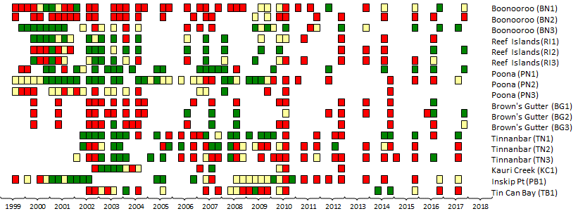
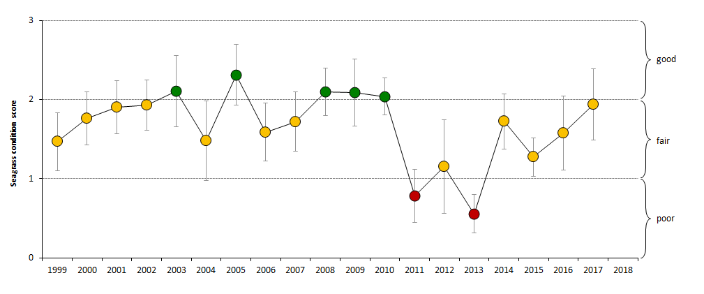
Seagrass meadows in the Great Sandy Strait region were classified as fair in abundance in 2017. - Seagrass abundance in the Great Sandy Strait has fluctuated since 1999 (fair to good to poor and back to fair), but there is no apparent long-term trend.
- Species composition has remained stable across the sites.
Macroalgae abundance is generally low, but seasonally increases in the middle of each year at most sites. Episodic algal blooms occurred in mid 2002. - Epiphyte blooms regularly occur at most sites in the mid-latter part of the year, with a dramatic decline in the summer months. Epiphyte abundance has continued to increase (not significantly) at some sites on the western shores of the Great Sandy Strait.
- Sediment grain size has remained relatively stable of the monitoring period, with only a few sites becoming either more muddy or more sandy.
- Seagrass-Watch data provides understanding of seasonal trends and effects of climatic patterns on seagrass meadows
- Management controls depend on public and government support.
Location
Brown's Gutter
Monitoring: suspended
Past watchers: Maree Prior, Norma Sanderson, Kate Houley, Kath Nash, Gordon Cottle, Robyn Bailey, Bruce Pollard, Sarah Mitchell, Lyn McPherson, Jess Milne, Graham Naughton, Ian Smith, Glen Miller, Bonnie Prior, Pat Cottle, Paul Bailey, Gary Nielsen, Steve Winderlich, John Lindberg, John Roberts, Anne O’Dae, Matthew Hamilton, Hanne Larsen & Seagrass-Watch HQ
Location: shallow anchorage on the south western shores of K’gari (Fraser Island)
Site codes: BG1, BG2, BG3
Issues: stormwater & land runoff, boat traffic
Comments: dugong and turtle feeding grounds
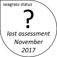
- seagrass abundance at Brown’s Gutter was in a Good state when last examined in November 2017
- Prior to the extreme climatic events of 2011, seagrass abundance at BG1 had progressively increased, however at BG2 & BG3 abundances had fluctuated greatly
- Post 2011, seagrass recovery occurred over a period of 4-5 years
- episodic algal bloom occurred in mid 2002, however the algal abundances subsequently declined early in the new year. Epiphyte blooms regularly occur at most sites in the middle of the year.
- sediment grain size has changed little over the monitoring period.
species composition has remained stable – dominated by Zostera. - polychaete worms and gastropods (including mud whelks) common.
Seagrass cover, species composition and canopy height
Location
Boonooroo
Monitoring: ongoing, ad hoc
Principal watchers: Seagrass-Watch HQ
Occasional and past watchers: Maree Prior, Kate Houley, Norma Sanderson, Bruce Pollard, Gordon Cottle, Robyn Bailey, Pat Cottle, Leanne Talbot, Sarah Mitchell, Pete Burchett, Troy Aikenhead, Helene Hoksbergen, Jess Milne, Kath Nash, Lyn McPherson, Paul Bailey, John Roberts, Anne O’Dae, Steve Winderlich, Hanne Larsen, Wayne Mathews, Peter Lusk, Bill Alston, Trischelle Lowry, Faye Fergurson & Mary Starkey
Location: on the western shores of the Great Sandy Strait, adjacent to Boonooroo township, between Big Tuan Creek and Maroom. BN2 is located close to Big Tuan Creek and BN3 is located approximately 1.6km north, with BN1 midway between BN2 and BN3. BN2 is considered the “impacted” site and BN3 the “control”/”reference” site
Site codes: BN1, BN2, BN3
Issues: Small unsewered village, boat traffic & land use
Comments: significant nursery grounds for juvenile prawns and fish. Dugong and turtle feeding grounds.
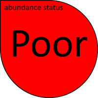
- seagrass abundance at Boonooroo is currently in a Poor state
- seagrass abundance at both “impacted” (BN1 & BN2) and “control” (BN3) sites declined from 1999 to 2005, however since 2005 seagrass abundance has continued to increase at BN3. Abundances similarly increased at BN1 & BN2 until 2010 when they declined.
- algae abundance appears seasonal at it generally increases in the middle of each year.
- epiphyte abundance, although highly variable, has continued to increase (not statistically significantly) over the monitoring period, possibly indicating elevated nutrients.
- sediment grain size has remained stable of the monitoring period.
dugong feeding trails found year round, with the most intensive grazing occurred from May to November, coinciding with the nutritional demands of calving from September to December. During this period seasonal forces support high seagrass growth ensuring that losses from grazing are outweighed by tissue production. - turtle feeding (cropping) was evident year round.
polychaete worms and gastropods (including mud whelks) were common. The diversity and abundance of gastropods appears to be dependent on seagrass abundance, most likely due to associated detrital and prey food sources. - species composition has varied over the monitoring period, particularly at BN1 where Zostera Mulleri was becoming more dominant until recently when the meadow reverted back to Halodule uninervis. Halodule uninervis and Halophila ovalis are colonising species and may indicate levels of physical disturbance (eg wave action and sediment movement).
Seagrass cover, species composition and canopy height
Location
Kauri Creek
Monitoring: suspended
Past watchers: Lyn McPherson, Norma Sanderson, Gordon Cottle, Robyn Bailey, Maree Prior, Pat Cottle, Paul Bailey, Steve Winderlich, Gary Nielsen, Wayne Mathews & Anne O’Dae
Location: on intertidal bank (Ballast Bank) on the southern side of the mouth to Kauri Creek
Site code: KC1
Issues: defence land runoff
Comments: dugong and turtle feeding grounds
- seagrass abundance at Kauri Creek was in a Poor state when last examined in June 2017
- seagrass abundance had fluctuated since monitoring was established, and abundances in 2010 were not significantly different from 2007.
- canopy height was showing a close correlation with seagrass abundance.
- epiphyte abundance appeared highly variable.
- sediment grain size and seagrass species composition appeared stable.
- polychaete worms and gastropods were common.
Seagrass cover, species composition and canopy height
Location
Poona
Monitoring: suspended
Occasional and past watchers: Norma Sanderson, Maree Prior, Lyn McPherson, Robyn Bailey, Jess Milne, Kath Nash, Gordon Cottle, Hanne Larsen, Gary Neilsen, Di-anne Duffield, Mary Dixon, Sarah De Ghen, Trischelle Lowry, Wayne Mathews, Desley Nielsen, Anne O’Dae, Steve Winderlich & Seagrass-Watch HQ
Location: intertidal banks adjacent to township
Site codes: PN1, PN2, PN3
Issues: small unsewered village increasing development, access channel dredging, boat traffic, stormwater, land runoff
Comments: significant fish habitat. Dugong and turtle feeding grounds
- seagrass abundance at Poona was in a Good state when last examined in September 2017
- seagrass abundance has fluctuated greatly since monitoring was established in 1999.
- seagrass composition appears relatively stable at PN1 and PN3.
PN2 has changed the most of all sites at Poona, both in abundance and species composition. The site appears to be generally dominated by Zostera Mulleri, however the composition of the colonising species Halodule uninervis and Halophila ovalis has fluctuated over the years and has become more dominant in 2008, suggesting a high level of localised physical disturbance. - sediment grain size has remained relatively stable at PN1 and PN2, however PN3 appears to have become muddier (this corresponds with the abundance of Zostera which is better adapted to muddier sediments).
- dugong feeding trails were found year round, with the most intensive grazing occurred from May to November, coinciding with the nutritional demands of calving from September to December. During this period seasonal forces support high seagrass growth ensuring that losses from grazing are outweighed by tissue production. Turtle feeding was evident year round.
- polychaete worms and gastropods were common. The diversity and abundance of gastropods appears to be dependent on seagrass abundance, most likely due to associated detrital and prey food sources.
- seagrass meadows at Poona were predominantly composed of fine mud and fine sand with a high organic component. Meadows near Poona Creek (PN2) had low seagrass cover, contained muddy sediments with a low sand component. At meadows distant from freshwater inputs (PN3) sand rippling indicates the influence of tidal movement and/or a low exposure to catchment influences.
Seagrass cover, species composition and canopy height
Location
Reef Islands
Monitoring: suspended
Occasional and past watchers: Maree Prior, Norma Sanderson, Kate Houley, Bruce Pollard, Gordon cottle, Robyn Bailey, Hanne Larson, Paul Bailey, Jimmy Joyce, Paul Sprecher, Graham Naughton, Ian Smith, Kerry, Peter Burchett, Sarah Mitchell, Troy Aithenhead, Steve Winderlich, John Roberts, Anne O’Dae, Gary Nielsen, Michael Ford, Sarah De Ghen, Bill Alston, Jerry Comans & Sue Olsson & Seagrass-Watch HQ
Location: central Great Sandy Strait
Site codes: RI1 RI2 RI3
Issues: Boat traffic, oyster leases, land runoff
Comments: significant nursery grounds for juvenile prawns and fish. Dugong and turtle feeding grounds

- seagrass abundance at the Reef Islands was in a Good state when last examined in September 2017
- seagrass abundance fluctuates (either doubling or halving) at times, but the long-term trend is stable.
- algal abundance is generally low with the exception being a significant algal bloom at RI1 in late 2003.
- epiphyte abundance appears seasonal with increases in the later part of the year, with a dramatic decline in the summer months.
- sediment grain size and species composition relatively stable over monitoring period.
- dugong feeding trails were found year round, with the most intensive grazing occurred from May to November, coinciding with the nutritional demands of calving from September to December. During this period seasonal forces support high seagrass growth ensuring that losses from grazing are outweighed by tissue production. Turtle feeding was evident year round.
- polychaete worms and gastropods were common. The diversity and abundance of gastropods appears to be dependent on seagrass abundance, most likely due to associated detrital and prey food sources. Filter feeding bivalves and oysters were found at Reef Island sites.
Seagrass cover, species composition and canopy height
Location
Tin Can Inlet
Monitoring: ongoing, ad hoc
Occasional and past watchers:Norma Sanderson, Maree Prior, Lyn McPherson, Robyn Bailey, Jess Milne, Kath Nash, Gordon Cottle, Hanne Larsen, Gary Neilsen, Di-anne Duffield, Mary Dixon, Sarah De Ghen, Trischelle Lowry, Wayne Mathews, Desley Nielsen, Anne O’Dae, Steve Winderlich & Seagrass-Watch HQ
Location: intertidal banks adjacent to township
Site codes: PB1, PB2, TB1
Issues: small unsewered village increasing development, access channel dredging, boat traffic, stormwater, land runoff
Comments: significant fish habitat. Dugong and turtle feeding grounds

- seagrass abundance at Tin Can Inlet is currently in a Fair state
- seagrass abundance has remained low (generally less than 1%) at the site adjacent to the Tin Can Bay township (TB1). The sparse meadows are dominated by the colonising seagrass species Halodule uninervis (narrow leaf morphology) and Halophila ovalis.
- The intertidal banks are dynamic (sand movement and physical disturbance from sting rays etc) and predominately sand with shell/gravel. Results suggest that due to the dynamic nature of the intertidal banks and the persistence of colonising species, the banks are adverse to establishment of dense seagrass meadows and little change would be expected in the near future.
- seagrass abundance at PB1 (Inskip Point) has fluctuated greatly over the monitoring period, however it has since decreased in 2008 to 1999-2000 abundances (ie post 1999 flood).
- the site at Bullock Point (PB2) in Pelican Bay was last monitored in August 2005.
- algal abundance appears to increase seasonally in the winter months and epiphyte abundance is highly variable. No persistent long-term trends are apparent, suggesting elevated nutrients are not a significant issue at present.
- seagrass composition at TB1 appears stable, although sediment grain size is variable.
- polychaete worms and gastropods (including mud whelks) were common. The diversity and abundance of gastropods appears to be dependent on seagrass abundance, most likely due to associated detrital and prey food sources.
- seagrass meadows at Pelican Bay were predominantly composed of fine mud and fine sand with a high organic component.
Seagrass cover, species composition and canopy height
Location
Tootoowah Creek
Monitoring: archived
Past watchers: Gordon Cottle, Robyn Bailey, Hanne Larson, Paul Bailey, Wendy Jones, Gary Nielsen, Steve Winderlich, Jerry Comans & Seagrass-Watch HQ
Location: Shallow anchorage on the western shores of Fraser Island.
Site codes: TC1, TC2
Issues: boat traffic, land runoff
Comments: dugong and turtle feeding grounds

- seagrass abundance at Tootoowah Creek was in a Poor state when last examined in June 2002
- sites have not been examined after nearly the entire loss of seagrass at the location was reported.
- Insufficient data to describe long-term trends
Seagrass cover, species composition and canopy height
Location
Tinnanbar
Monitoring: ongoing, ad hoc
Principal watchers: Seagrass-Watch HQ
Occasional and past watchers: Maree Prior, Norma Sanderson, Helen Bowyer, Darcy Bowyer, Lyn McPherson, Gordon Cottle, Robyn Bailey, Hanne Larson, Pat Cottle, Mike Oram, Nick Prior, Mars Oram, Bernard Bowyer, Ben Hoekstra, Nick Dennett, N Sanderson, Gary Nielsen, Peter Lusk, Wayne Mathews, Hans Van Roey, Sarah De Ghen, Steve Nicol, D. Eckert, Megan Dale, Nigel Woodward, Rex Coleman, Steve Winderlich
Location: southern Great Sandy Strait on the inter tidal banks in front of the Tinnanbar township & caravan park.
Site codes: TN1, TN2, TN3
Issues: high urban development, boat traffic, stormwater, land runoff
Comments: dugong and turtle feeding grounds. Popular fishing (recreational & commercial)

- seagrass abundance at Tinnanbar is currently in a Poor state
- seagrass abundance has fluctuated between years, reaching highest levels in 2002, 2008-09 and 2015. All sites decreased in abundance post 2017
- macroalgae cover is generally low and epiphyte cover is high and variable.
- sediment grain size and species composition relatively stable over monitoring period.
- polychaete worms and gastropods were common.
Seagrass cover, species composition and canopy height
Location
Wanggoolba & Bennett’s Creek
Monitoring: archived
Past watchers: Michael Ford, Anne O’Dae, Bill Alston, John Lindberg, Peter Lusk & Seagrass-Watch HQ
Location: On the western shores of Fraser Island in the northern Great Sandy Strait. Wanggoolba Creek is one of the main access points (ferry) to the World Heritage listed Fraser Island
Site codes: WC1, WC2
Issues: access dredging & spoil disposal, boat traffic
Comments: dugong and turtle feeding grounds. Wanggoolba Creek is a declared Fish Habitat Areas (FHA) to enhance existing and future fishing activities and to protect the habitat upon which fish and other aquatic fauna depend.

- seagrass abundance at Wanggoolba and Bennett’s Creek was in a Good state when last examined in July 2004
- seagrass abundance recovered significantly after it was lost in February 1999, the result of a major flood.
- canopy height continued to increase at the site in close correlation with seagrass abundance.
- macroalgae cover is relatively insignificant at these sites. Irregular epiphyte blooms occur at both sites from time to time.
- sediment grain size appears to be less muddy, with more sand present.
- seagrass species composition relatively stable over monitoring period.
- dugong feeding was absent until late 2001, coinciding with seagrass recovery. Feeding trails are regularly observed across the meadows.