Western Australia

The Kimberley region of Western Australia extends from the border with the Northern Territory in the north east to Sandy Point (Roebuck Bay) in the south. The marine ecosystems are characterised within the North-West Marine Bioregion1. Seagrasses are a significant component in the coastal marine ecosystems2,3,4,5 and their contribution to the total primary carbon production is critical to regionally important dugong and turtle populations.

The Kimberley coast displays wide variation and is a significant component of the region’s physical setting. It is a typical drowned river valley system, with wide sandy beaches which give way to mudflats. Embayments and sounds grade shorewards into mangrove lined tidal flats. Mangrove inlets and tidal creeks are interspersed with coastal cliffs. Some embayments such as Cambridge Gulf and King Sound extend well inland. There are numerous offshore islands and much of the coast remains uninhabited.

The Kimberley coast region of Western Australia has both arid and wet tropical environments (annual average rainfall <200 mm and >1000 mm respectively). The marine environment is influenced by the warm, south-equatorial current that flows from the east through the south east Asian and northern Australian region. The coast is prone to large tidal variation from <1 to 11m6. In King Sound, the highest tides reach 11m. Strong tidal flows, together with summer river discharges, dramatically influence the coastal environment.

Western Australia has the highest diversity of seagrasses in the world, with 25 species represented6,7,8. These are generally divided into temperate and tropical distributions, with Shark Bay representing the biogeographical overlap. 12 species are represented in the tropics (Thalassia hemprichii, Thalassodendron ciliatum, Enhalus acoroides, Halophila ovalis, Halodule uninervis, Halophila minor (revised from H. ovataa ), Cymodocea angustata, Syringodium isoetifolium, Cymodocea serrulata, Halophila spinulosa, Halodule pinifolia and Halophila decipiens), one of which is endemic (Cymodocea angustata)7,8.

Seagrass distribution throughout the region is most likely influenced by shelter, sediment characteristics, water turbidity and tidal exposure. Seagrass meadows are mostly found in the sheltered bays along the southern mainland coast. Extensive terracing of these expanses of the intertidal zone often result in seagrass high in the intertidal8. The majority of the meadows are low to moderate in abundance, and are dominated by Halophila and Halodule species. Seagrasses either occur sparsely in coral reef environments or can attain high biomasses on mudbanks or within high intertidal lagoons, where water is ponded during the falling tide. The environments are otherwise too extreme (tidal movement/ turbidity/ freshwater runoff in the wet season) for seagrass survival10. Subtidal populations of seagrasses are poorly known, but it appears that the northern Kimberley does not have the seagrass richness recorded for the southern Kimberley.

Seagrass-Watch in the Kimberely Region

To provide an early warning of change, long-term monitoring has been established in Roebuck Bay and Dampier Peninsula as part of the Seagrass-Watch, Global Seagrass Observing Network (www.seagrasswatch.org). Establishing a network of monitoring sites in Kimberley region provides valuable information on temporal trends in the health status of seagrass meadows in the region and provides a tool for decision-makers in adopting protective measures. It encourages local communities to become involved in seagrass management and protection. Working with both scientists and local stakeholders, this approach is designed to draw attention to the many local anthropogenic impacts on seagrass meadows which degrade coastal ecosystems and decrease their yield of natural resources.

Location

Roebuck Bay

Roebuck Bay is a tropical marine embayment with extensive, highly biologically diverse, intertidal mudflats. The Bay is bounded to the north-west by the township of Broome (population 13,984 in 2016) and extends to Sandy Point in the south.

Seagrass communities are a critical component of the Roebuck Bay marine system, forming extensive meadows in the lower intertidal areas, particularly in the northern Bay6,11. Dugongs and green turtles use the bay as a feeding and migration transit area. Aerial surveys in 2009 from Lagrange Bay in the south to Cape Leveque in the north, estimated the dugong population of Roebuck Bay to be 542 (SE: ±216) individuals in the late wet season (March), 709 (95% CI: 455 – 952) in the dry season (July) and 531 (95% CI: 274 – 811) in September12. These were significantly higher than the 50-100 individuals previously reported in 198413. The 2009 surveys also reported that Roebuck Bay supported the greatest number of calves in the region and in all survey periods12.

Roebuck Bay is also a major nursery for fishes and crustaceans, supporting an exceptionally high biomass and diversity of benthic invertebrates (approximately 300 – 500 species), placing it among the most diverse mudflats known in the world14. As a Ramsar site, Roebuck Bay is one of the most important sites for shorebird conservation in the East Asian-Australasian Flyway in Australia and globally.

For the Yawuru traditional owners of Roebuck Bay, the Bay is of immense cultural importance due to the important food and ceremonial species it contains many which rely on seagrass (e.g., dugong), as well as the many connections to dreaming stories, law and other spiritual and cultural practices15.

Roebuck Bay has a very large tidal range which exposes around 160 km2 of mudflat, approximately 45% of the total bay area, with tides travelling at up to 20cm/sec mid cycle16,17. Most of the mudflat area is inundated by each high tide and at times, spring tides and/or cyclones may cause the adjoining coastal flats to become inundated. The tidal system is semi-diurnal with an average tidal amplitude of 5.7m. Tidal range varies from c. 1 m on neap tides to 10.5 m on the highest spring tides. These factors dominate the intertidal ecology.

The extensive seagrass meadows in the northern regions of Roebuck Bay, particularly in the Town Beach area, are dominated by Halophila ovalis and Halodule uninervis, with a further two species (Halodule pinifolia and Halophila minor) under review for synonymy18. The most vigorous stands of seagrass grow in areas that are exposed for less than two hours at low tide19.

Monitoring: ongoing, triannual
Principal watchers: Fiona West, Ayesha Moss, Carla Eisemberg, Chris Nutt, Connie Grohmann, Dianne Bennett, Kylie Weatherall, Gary Lienert, Heather Beswick, Jon Hall, Juanet West, Julia Rau, Kandy Curran, Matt MacDonald, Sam Younis, Kevin Smith, Neil Hamaguchi, Kent Dequito, Liz Kent, Malcolm Lindsay, Michelle Teoh, Pat Lowe , Rose Barker, Stacey Newton , Tessa Mossop
Location: intertidal sand flat in the northern section of the bay between the port and Black Ledge.
Site code: RO1, RO2, RO3, RO4
Issues: Urban runoff
Comments: Extensive seagrass meadows occur in the northern regions of Roebuck Bay, particularly in the Town Beach area, and are dominated by Halophila ovalis and Halodule uninervis. Most abundant sections are where pooling of water occurs at low tide. Dugong feeding trails are common.

Good seagrass abundance status
  • seagrass abundance (% cover) follows a unimodal pattern of growth annually, with higher abundances in late-dry to early-monsoon (October-December) and lower in late-monsoon to dry (April-July) seasons of each year.
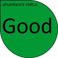
  • Seagrass abundance relative to the seagrass guidelines indicates that the seagrass meadows across Roebuck Bay are currently in a Good state (March 2022) and have remained in a Good state at all long-term monitoring sites over the last 12 months (since late February-early March 2021).

  • seagrass abundance appears to be primarily driven by environmental factors which modify the interactive effect of sea water temperature (over preceding 2 weeks) and light availability. A dominate negative influence on available light appears to be runoff from seasonal rainfall in the preceding 3 months.
  • over the last few years, seagrass abundances improved at RO1 and RO2 (late dry 2018), remaining in a Good state. At RO3, however, abundance remained in a Poor state, from declines experienced in 2017 and 2018, until late-dry 2020 when abundances improved.
  • although seagrass abundance fluctuated between years, there were no detectable long-term trends at any site.
  • the opportunistic foundational species Halodule uninervis dominates the meadows in both abundance and canopy height. The colonising species Halophila ovalis fluctuated seasonally in composition, declining in the wet season (monsoon and late-monsoon).
  • Epiphyte abundance is generally similar across all sites, being significantly higher in 2007–2009 and 2013–2014. Abundances appear greater in late-dry/early monsoon of each year, most likely owing to increasing daylight paired with moderate temperatures.
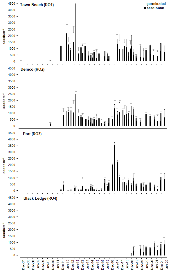
  • A seed bank of the foundation seagrass Halodule uninervis persists at all sites, and although highly variable, densities appeared higher in the wet (December to May), after the main seagrass growing period (August to December). Analysis suggests that meadows may require only a moderate seed bank for recovery capacity, and that greater sized seed banks provide greater probability of recovery (i.e. greater probability of viable seeds) but not necessarily greater abundance18.

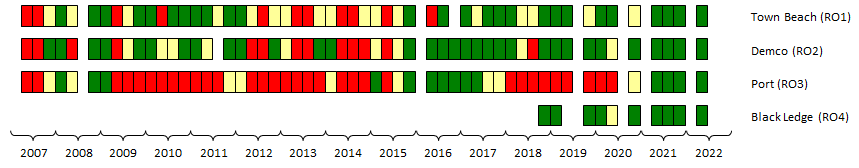
The report card represents the annual relative health of seagrass in Roebuck Bay, and shows that seagrass condition has fluctuated over the 15 years of monitoring. Seagrass condition was in a Fair state when monitoring was established in 2007, but improved to Good (A grade) the following year, where it remained until 2014. In 2014 seagrass condition declined to Fair, a consequence of lower abundances and fewer seeds, but in 2016 seagrass recovered back to a Good state (grade A), where it has remained since. Although seagrass state remained Good in 2020, it was lowest score in 5 years due to declining seed banks. In 2021, the improving seagrass seagrass abundance coupled with a large persistent seed bank suggests resilient seagrass with an overall status of Good

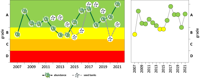
Seagrass condition report card for Roebuck Bay: the first figure shows the annual trend in the two indicators, abundance and seedbank; the second figure shows the annual index (combined indicator scores). Grade A / Green = ‘good’ seagrass health, to Grade D / Red = ‘very poor’. For more detail of report card scoring see McKenzie et al. 201718.

Seagrass cover, species composition and canopy height

Cover

Composition
Height

Macroalgae and Epiphyte cover

Algae

Epiphyte

  • Seagrass are flowering plants which produce fruits and seeds. Some seagrass seeds persist in seabed sediments for several years, forming a bank from which meadows can recover when plants are lost or disturbed. A persistent seed bank of the foundation seagrass Halodule uninervis exists throughout the meadows of northern Roebuck Bay. Although highly variable, densities appear higher in the wet season (December to May) after the main seagrass growth period (September to December). Analysis suggests that meadows may require only a moderate seed bank for recovery capacity, and that greater sized seed banks provide greater probability of recovery (i.e. greater probability of viable seeds) but not necessarily greater abundance.
Location

Dampier Peninsula

Monitoring: suspended
Occasional and past watchers: Bardi Jawi Land and Sea Rangers (Damon Pyke, Trevor Sampi, Chris Sampi, Nathan Sampi, Kevin George, Dwayne George, Phillip McCarthy, Terry McCarthy, Mark Shadforth), Todd Quartermaine
Location: One Arm Point
Site code: OA1
Issues: none identified
Comments: The most diverse seagrass meadows in the Kimberley region have been reported on the reef platforms in the One Arm Point. Dugongs and turtles are often reported feeding on these meadows.
It is unknown if the seagrasses of the Dampier Peninsula have changed significantly since the 1980’s.

Status unknown
  • only 1 site established (no replication due to size of meadow)
  • site only contains Thalassia hemprichii
  • abundances in 2013 were the lowest since monitoring was established in 2009.
  • long-term trend suggests seagrass abundance was declining.

Seagrass cover, species composition and canopy height

Cover
Composition
Height

Macroalgae and Epiphyte cover

Algae
Epiphyte